Miami Florida Marine Forecast Interactive Clickable Zone Map
Marine forecast zone from the state of Florida Miami NOAA office which include the Gulf of Mexico, Atlantic, coastal waters, bays and offshore. Marine forecast areas included are Jupiter Inlet, Juno Beach, Palm Beach, Delray Beach, Fort Lauderdale, Hollywood, Miami Beach, Miami, Key Biscayne, Biscayne Bay, North key Largo, Cape Sable, Everglades City, Chokoloskee, Cape Romano, Goodland, Marco Island, Naples and Bonita Springs Beach
Click any zone on the map below to retrieve forecast
Miami Marine Forecast Zone Map
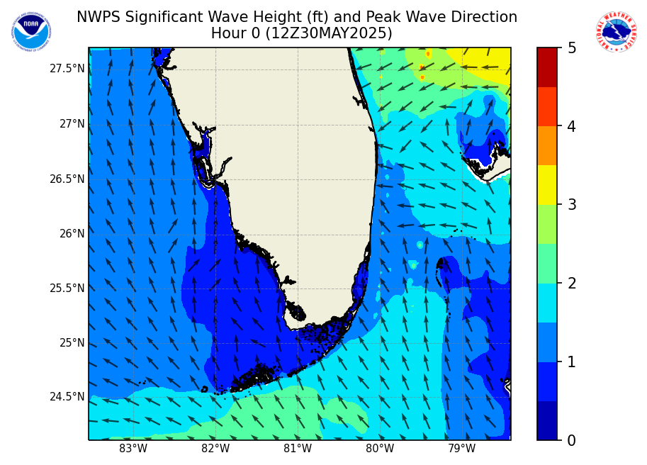
Significant Wave Height Forecast


Marine forecasts are issued at least four times a day. Advisories, watches and warnings for marine areas are issued as required. Internet forecasts should never be relied upon to obtain the latest forecast and warning data. Use other means such as NOAA Weather Radio to obtain the latest forecasts and warnings.
Miami Zone Marine Forecast Text Links
-
AMZ651 Coastal waters from Deerfield Beach to Ocean Reef FL out 20 NM
-
AMZ650 Coastal waters from Jupiter Inlet to Deerfield Beach FL out 20 NM
-
AMZ670 Waters from Jupiter Inlet to Deerfield Beach FL from 20 to 60 NM
-
AMZ671 Waters from Deerfield Beach to Ocean Reef FL from 20 to 60 NM
-
GMZ657 Coastal waters from East Cape Sable to Chokoloskee FL out 20 NM
-
GMZ656 Coastal waters from Chokoloskee to Bonita Beach FL out 20 NM
-
GMZ676 Waters from Chokoloskee to Bonita Beach FL from 20 to 60 NM
For more marine forecast information for the Miami zone visit the following office website:
Synopsis for Jupiter Inlet to Ocean Reef FL out to 60 nm and for East Cape Sable to Bonita Beach FL out to 60 nm
Expires:202608010900;;406995 FZUS52 KMFL 312021 CWFMFL Coastal Waters Forecast for Florida National Weather Service Miami FL 421 PM EDT Fri Jul 31 2026 Atlantic coastal waters from Jupiter Inlet to Ocean Reef out to 60 nm and Gulf coastal waters from East Cape Sable to Chokoloskee out 20 nm and Chokoloskee to Bonita Beach out 60 nm...including the waters of Biscayne Bay and Lake Okeechobee. Seas are provided as a range of the average height of the highest 1/3 of the waves...along with the occasional height of the average highest 10 percent of the waves. AMZ600-GMZ606-010900- 421 PM EDT Fri Jul 31 2026 .Synopsis for Jupiter Inlet to Ocean Reef FL out to 60 nm and for East Cape Sable to Bonita Beach FL out to 60 nm... Moderate west-southwest winds continue through the weekend, except for afternoon periods of southerly winds at the Atlantic waters this afternoon. Isolated to scattered thunderstorms are possible each day, which may result in brief periods of rough seas and gusty winds. In general, seas are expected to remain around 2 ft through the forecast period. Gulf Stream Hazards: None The approximate location of the west wall of the Gulf Stream as of Jul 29, 2026. 16 nautical miles north northeast of Fowey Rocks. 10 nautical miles northeast of Port Everglades. 3 nautical miles east northeast of Lake Worth. 6 nautical miles east northeast of Jupiter Inlet. This data courtesy of the Naval Oceanographic Office. $$ |