Live Hurricane Tracker & Real-Time Storm Map
Stay ahead of severe weather with our live hurricane tracker, interactive storm maps, and real-time tropical weather dashboard. This dynamic tracking tool aggregates instant updates, projected cone models, and live data directly from official meteorological sources. By delivering precise projected paths and vital safety alerts when every second counts, this hurricane and tropical outlook tracker provides the accurate data users need to make informed decisions.
Live Hurricane Tracker
Interact with our live hurricane tracker map by customizing your view using the map layers button on the left side from the map above. Check the links below for automated NHC weather feed updates from the tropical weather blog.
Hurricane Future Forecast
Press play to put future forecast in motion.

Tropical Cyclone Genesis and Formation Probability


Latest Tropical Weather Blog Posts
Hurricane Blogs from The Eyewall and Tropical Tidbits.
NHC YouTube Video Updates
Latest NHC YouTube Updates.
Tropical Weather Outlook Graphics


Tropical Weather Outlook Text
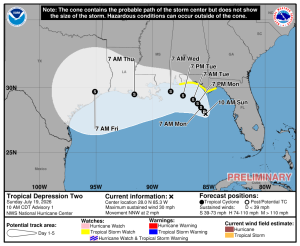
000
ABNT20 KNHC 192344
TWOAT

Tropical Weather Outlook
NWS National Hurricane Center Miami FL
800 PM EDT Sun Jul 19 2026

For the North Atlantic...Caribbean Sea and the Gulf of America:

Active Systems:
The National Hurricane Center is issuing advisories on Tropical
Depression Two, located over the northeastern Gulf of America.

Tropical cyclone formation is not expected during the next 7 days.

&&
Public Advisories on Tropical Depression Two are issued
under WMO header WTNT32 KNHC and under AWIPS header MIATCPAT2.
Forecast/Advisories on Tropical Depression Two are issued
under WMO header WTNT22 KNHC and under AWIPS header MIATCMAT2.

$$
Forecaster D. Zelinsky