Update (July 4, 12:45 p.m. EDT): As of 12Z (8 a.m. EDT) Saturday morning, the sustained winds of Super Typhoon Bavi were 160 mph (260 km/h), according to the Joint Typhoon Warning Center (JTWC). As of 15Z Saturday, Bavi’s central pressure was at 920 mb, according to the Japan Meteorological Agency. Satellite imagery and other data showed that a partial eyewall replacement cycle was under way, which could bring down Bavi’s strength slightly. However, JTWC predicts that the storm will remain a super typhoon, and it could restrengthen on Sunday. The longer-range forecast below has changed little: as it tracks steadily west-northwestward, Bavi is expected to approach the U.S. Northern Mariana Islands between 18Z Sunday and 0Z Monday, and it remains a potential threat to eastern Asia late next week.
Original article, posted on Friday, June 3:
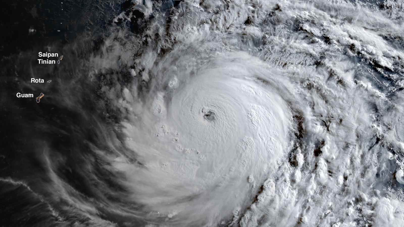
Typhoon Bavi put on a rare display of rapid intensification over the warm Pacific waters east of Guam on Thursday and Friday, becoming the world’s third Category 5 tropical cyclone of the year at 2 p.m. EDT July 3, with 160 mph (260 km/h) winds, according to the Joint Typhoon Warning Center (JTWC). Bavi intensified by 75 mph (120 km/h) in the 24 hours ending at 12Z Friday, and 100 mph (160 km/h) in the 36 hours ending at 18Z Friday — far exceeding the official definition of rapid intensification of a 35 mph increase in winds in 24 hours.
At 21Z Friday, the Japan Meteorological Agency, the official agency responsible for typhoon warnings in the Northwest Pacific, estimated that Bavi’s central pressure was 935 mb, with 110 mph (175 km/h) winds (10-minute average, which is normally substantially lower than the 1-minute average used by the Joint Typhoon Warning Center).
Bavi took advantage of favorable conditions for its extreme rapid intensification: low wind shear of 5-10 knots, sea surface temperatures of 29-30 degrees Celsius (84-86°F), with warm waters that extended to great depth (an ocean heat content over 110 kilojoules per square centimeter).

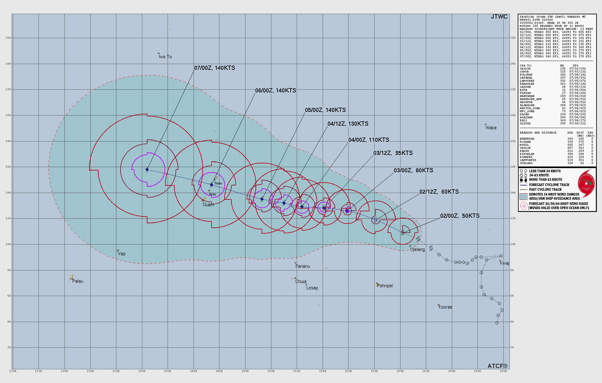
Two-day forecast for Bavi
The Joint Typhoon Warning Center is predicting that Bavi will peak with 175 mph winds at 6Z Sunday, then slightly weaken because of an eyewall replacement cycle by Sunday afternoon (U.S. EST, but early Monday morning local time in the Northern Marianas) as it moves through the U.S. Northern Mariana Islands. The ridge of high pressure steering the typhoon is not expected to change much, and the track of the storm will very likely carry it just south of or over Tinian and Saipan islands in the Northern Marianas as early as 18Z Sunday. This passage could occur as late as 02Z Monday, according to the latest run of the GFS model. At landfall, JTWC predicts that Bavi will be a Category 5 storm with 165 mph (270 km/h) winds.
The National Weather Service in Guam issued a Typhoon Watch early Saturday local time for Guam, Rota, Tinian, and Saipan, warning of sustained winds of 175 mph, with gusts to 210 mph. Seas up to 45 feet were predicted for offshore waters, and 25-35 feet along the east-facing reefs. The Weather Service warned of catastrophic damage occurring where the eyewall passes.

Long-range forecast for Bavi
Once Bavi passes the Northern Mariana Islands, atmospheric and ocean conditions are not expected to change much. The ridge of high pressure steering the typhoon will continue to take Bavi to the west-northwest, resulting in a threat to Taiwan or China by Friday, July 10. Intensity forecasts that far out are unreliable, but the European and GFS models indicate Bavi will maintain strength as a major typhoon until landfall in Asia.
Bavi is the third Cat 5 of 2026
Bavi is the third Cat 5 globally this year. The others were:
Super Typhoon Sinlaku, 185 mph (295 km/hr) winds, Apr. 12, 2026, southeast of Guam. Sinlaku made landfall over the U.S. Northern Mariana Islands on April 14, with the large eye of the storm passing over both Tinian and Saipan islands simultaneously. According to the Joint Typhoon Warning Center (JTWC), Sinlaku was a Cat 4 with sustained winds of 145 mph (230 km/hr) at landfall. Sinkalu killed 17 and did about $1.5 billion in damage to the Northern Mariana Islands and Guam. Sinlaku was the 10th Category 4 or 5 tropical cyclone to hit a U.S. state or territory in the past 10 years — as many Cat 4 and Cat 5 landfalls as the U.S. suffered in the prior 57 years.
Tropical Cyclone Horacio, 160 mph (260 km/h) winds, Feb. 23, 2026, over the remote South Indian Ocean. Horacio did not impact any land areas.
How strong can Bavi get?
As I detailed in my April post How strong can a hurricane get in a warming world?, the maximum potential intensity (MPI) of a tropical cyclone is the maximum strength a storm can achieve based on the existing atmospheric and oceanic conditions. Potential intensity theory was pioneered in 1987 by MIT hurricane scientist Kerry Emanuel, who showed that human-caused global warming will increase the maximum strength that a tropical cyclone can achieve.
Bavi is approaching its maximum potential intensity, which is expected to be about 200 mph with a central pressure of 880 mb, according to a graphic from the University of Wisconsin CIMSS. It is quite rare for a hurricane or typhoon to reach its maximum potential intensity — all conditions have to be perfect, and the atmosphere and ocean make up a complex system where perfection is rarely achieved. An eyewall replacement cycle will likely interrupt Bavi’s intensification process sometime in the next two days, leaving the typhoon short of its MPI.

El Niño supercharges typhoon seasons
Bavi is the classic early-season super typhoon one would expect to see when the ocean-atmosphere system is moving into a strong El Niño event, as is currently the case. Typhoons tend to form farther east, away from Asia, during an El Niño episode because of warmer waters in the Central Pacific. Thus, El Niño-year typhoons take longer tracks over water before recurving or hitting Asia, resulting in a greater chance of reaching Category 5 intensity.
Over the 79 years of Joint Typhoon Warning Center monitoring, there have been 317 super typhoons — defined as having maximum sustained 1-minute average winds of at least 150 mph (240 km/hr) — with an average frequency of around four per year. Most of these reach the Cat 5 threshold (winds of at least 156 mph). The strong El Niño year of 1997 saw 11 super typhoons in the Northwest Pacific, with a record 10 Cat 5s, and a record accumulated cyclone energy (ACE) index of 594.
The 1990-2025 average yearly number of Category 5 storms globally was 5.3; there were five in 2025 (Hurricanes Melissa, Erin, and Humberto in the Atlantic; Typhoon Ragasa in the Northwest Pacific; and Cyclone Errol in the South Indian).
As seen in Fig. 3, the number of Cat 5s has increased globally since accurate global satellite data became available in 1982 (this increase is statistically significant at the 99.5% level). Climate change is expected to increase the proportion of tropical cyclones reaching Category 4 or 5 strength.
Bob Henson and Irene Sans contributed to this post.
![]()
Source link