| Mesoscale Discussion 964 | |
| < Previous MD | |

|
|
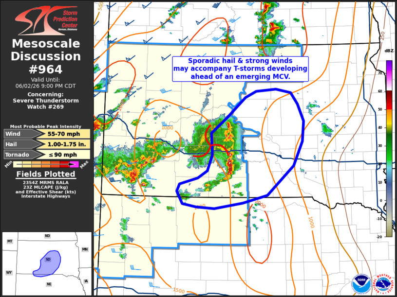
Mesoscale Discussion 0964 NWS Storm Prediction Center Norman OK 0656 PM CDT Tue Jun 02 2026 Areas affected...Far northern Nebraska into central South Dakota Concerning...Severe Thunderstorm Watch 269... Valid 022356Z - 030200Z The severe weather threat for Severe Thunderstorm Watch 269 continues. SUMMARY...Thunderstorms developing in proximity to an emerging MCV may periodically pose a threat for large hail and perhaps damaging downburst winds. However, the longevity and coverage of this threat is uncertain given poor environmental wind shear. Downstream watch issuance will most likely not be needed. DISCUSSION...Over the past hour, regional radar imagery shows the gradual emergence of a weak MCV associated with a persistent convective cluster across south-central SD. New convection continues to develop in proximity to this feature and along a composite outflow boundary that is gradually pushing south. Despite this trend, MRMS data shows that attendant convection has been mostly short-lived (on the order of an hour or less) and only occasionally intensifying to severe limits. This is likely a result of diminishing mid and upper-level flow with southeastward extent that is modulating overall storm organization/longevity. Nonetheless, latest RAP mesoanalysis estimate suggest this MCV is approaching a regional buoyancy maximum where MLCAPE is upwards of around 2000 J/kg. This, combined with increasing ascent on the southern fringe of the MCV/cold pool as the nocturnal jet intensifies, may support an increase in thunderstorms and potentially sporadic large hail and strong/severe downburst winds. Given the poor kinematics, any severe threat will likely be localized and short lived, which should preclude the need for downstream watch issuance (though trends will continue to be monitored). ..Moore.. 06/02/2026 ...Please see www.spc.noaa.gov for graphic product... ATTN...WFO...FSD...ABR...LBF...UNR... LAT...LON 44240116 44550073 44920025 45049996 45089944 45019903 44809886 44479870 44079873 43619898 43049968 42890032 42780108 42800156 42860191 43100207 43250199 43360152 43510126 43810114 44240116 MOST PROBABLE PEAK TORNADO INTENSITY...UP TO 90 MPH MOST PROBABLE PEAK WIND GUST...55-70 MPH MOST PROBABLE PEAK HAIL SIZE...1.00-1.75 IN |
|
|
Top/All Mesoscale Discussions/Forecast Products/Home |
|
Source link