| Mesoscale Discussion 963 | |
| < Previous MD | |

|
|
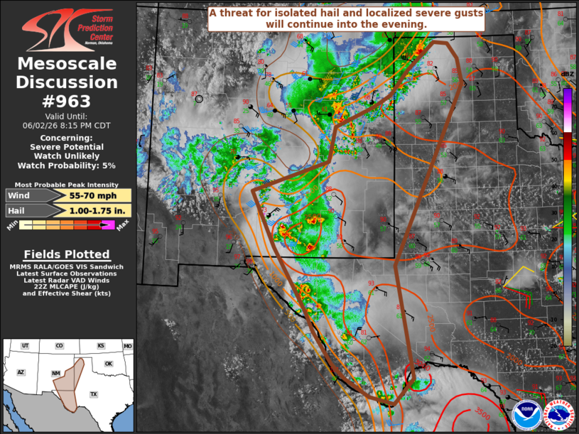
   Mesoscale Discussion 0963
   NWS Storm Prediction Center Norman OK
   0548 PM CDT Tue Jun 02 2026

   Areas affected...Parts of south-central and eastern NM into west TX

   Concerning...Severe potential...Watch unlikely

   Valid 022248Z - 030115Z

   Probability of Watch Issuance...5 percent

   SUMMARY...A threat for isolated hail and localized severe gusts will
   continue into the evening.

   DISCUSSION...Several slow-moving but vigorous storms are ongoing
   from parts of south-central/eastern NM into Far West TX as of 2230
   UTC, while more isolated strong storms have moved into the western
   TX Panhandle. Strong heating and relatively moist low-level
   east-southeasterly flow beneath steep midlevel lapse rates has
   resulted in moderate to strong destabilization, with MLCAPE of
   greater than 2000 J/kg in place outside of areas already influenced
   by convective outflow.

   Deep-layer flow is generally weak, but the backed low-level flow
   veering to weak south-southwesterlies aloft is supporting effective
   shear of 20-25 kt, with locally greater values over parts of NM. In
   conjunction with the favorable instability, this magnitude of
   deep-layer will continue to support potential for strong multicells
   and perhaps a transient slow-moving supercell, with attendant
   potential for isolated hail and localized severe gusts. Some
   consolidation of outflow is possible with time, which could result
   in a somewhat broader area of strong to locally severe gusts from
   eastern NM into parts of west TX this evening, before convection
   generally weakens with the onset of nocturnal cooling/stabilization.

   ..Dean/Guyer.. 06/02/2026

   ...Please see www.spc.noaa.gov for graphic product...

   ATTN...WFO...LUB...AMA...MAF...ABQ...EPZ...

   LAT...LON   30920518 32200594 33330650 33960465 34660449 35080352
               35320312 35830269 36400204 36370169 36060146 35540134
               33760218 31830304 29550262 29030308 29180368 29550425
               29840455 30490498 30920518

   MOST PROBABLE PEAK WIND GUST...55-70 MPH
   MOST PROBABLE PEAK HAIL SIZE...1.00-1.75 IN
|
|
|
Top/All Mesoscale Discussions/Forecast Products/Home |
|
Source link