| Mesoscale Discussion 952 | |
| < Previous MD | |

|
|
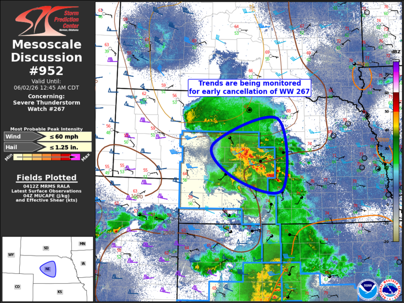
Mesoscale Discussion 0952 NWS Storm Prediction Center Norman OK 1114 PM CDT Mon Jun 01 2026 Areas affected...portions of central Nebraska Concerning...Severe Thunderstorm Watch 267... Valid 020414Z - 020545Z The severe weather threat for Severe Thunderstorm Watch 267 continues. SUMMARY...Thunderstorms continue to congeal into a large complex across central Nebraska. The overall environment continues to become less favorable for large hail or damaging winds. Severe Thunderstorm Watch #267 may need to be canceled early. DISCUSSION...Thunderstorms have congealed into a large, non-severe mesoscale convective system this evening across central Nebraska. The thermodynamic environment is weaker than before, with MUCAPE values generally at or below 1000 J/kg across the complex, and should continue to decrease ahead of the northeastward moving MCS. Additionally, deep-layer shear has weakened from earlier to generally at or below 30 knots along and ahead of the MCS. Thus, absent any notable uptick in thunderstorm intensity, Severe Thunderstorm Watch #267 may need to be canceled early. Trends will be monitored. ..Marsh.. 06/02/2026 ...Please see www.spc.noaa.gov for graphic product... ATTN...WFO...GID...LBF... LAT...LON 40789897 41020040 41780107 42399913 40789897 MOST PROBABLE PEAK WIND GUST...UP TO 60 MPH MOST PROBABLE PEAK HAIL SIZE...UP TO 1.25 IN |
|
|
Top/All Mesoscale Discussions/Forecast Products/Home |
|
Source link