| Mesoscale Discussion 921 | |
| < Previous MD | |

|
|
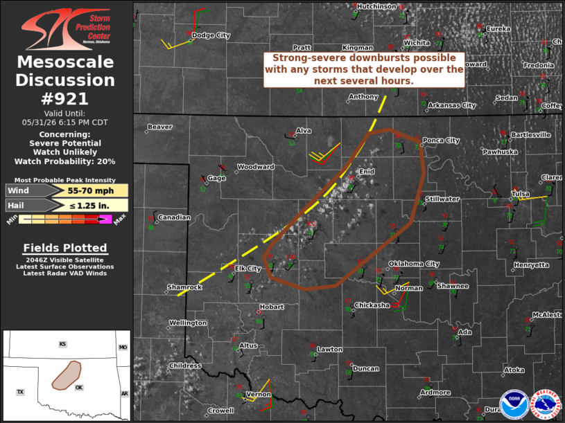
   Mesoscale Discussion 0921
   NWS Storm Prediction Center Norman OK
   0350 PM CDT Sun May 31 2026

   Areas affected...Parts of northwest and north-central Oklahoma

   Concerning...Severe potential...Watch unlikely

   Valid 312050Z - 312315Z

   Probability of Watch Issuance...20 percent

   SUMMARY...Isolated strong-severe downbursts are possible with any
   storms that develop over the next several hours.

   DISCUSSION...Visible satellite imagery shows deepening high-based
   cumulus evolving within a zone of low-level confluence in
   north-central and northwest OK -- where a sharp gradient in
   low-level moisture and boundary-layer mixing is evident. Continued
   heating in this zone should eventually support the development of
   isolated thunderstorms this afternoon. Temperatures in the upper 90s
   amid middle/upper 60s dewpoints are yielding a favorable environment
   for strong to severe downbursts. Around 30 kt of effective shear in
   the northern part of the area will conditionally favor storm
   organization and a locally greater severe risk, though most storms
   are expected to remain short-lived.

   ..Weinman/Thompson.. 05/31/2026

   ...Please see www.spc.noaa.gov for graphic product...

   ATTN...WFO...OUN...

   LAT...LON   35589905 35729894 36059858 36489805 36829776 36879751
               36749713 36429708 35939724 35299817 35269854 35379897
               35589905

   MOST PROBABLE PEAK WIND GUST...55-70 MPH
   MOST PROBABLE PEAK HAIL SIZE...UP TO 1.25 IN
|
|
|
Top/All Mesoscale Discussions/Forecast Products/Home |
|
Source link