| Mesoscale Discussion 919 | |
| < Previous MD | |

|
|
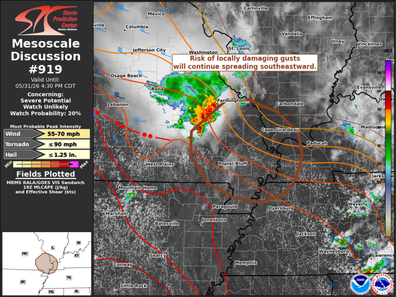
   Mesoscale Discussion 0919
   NWS Storm Prediction Center Norman OK
   0230 PM CDT Sun May 31 2026

   Areas affected...Southeast MO...far southern IL...far western
   KY...and far northwest TN

   Concerning...Severe potential...Watch unlikely

   Valid 311930Z - 312130Z

   Probability of Watch Issuance...20 percent

   SUMMARY...Locally damaging gusts will be possible with a cluster of
   thunderstorms tracking southeastward.

   DISCUSSION...A loosely organized cluster of thunderstorms is
   tracking southeastward across southeastern MO, which has produced a
   few damaging gusts and small hail. Despite limited deep-layer shear
   (around 25-kt midlevel flow per regional VWP), warm/moist inflow and
   steepened lapse rates (around 2000 J/kg MLCAPE) will continue to
   maintain this activity as it continues southeastward along the CAPE
   gradient over the next couple hours. Locally damaging gusts will
   remain possible, but current thinking is that the overall severe
   risk will remain too limited for a watch.

   ..Weinman/Thompson.. 05/31/2026

   ...Please see www.spc.noaa.gov for graphic product...

   ATTN...WFO...PAH...MEG...LSX...

   LAT...LON   36959092 37339092 37859020 37858975 37648918 37308875
               36858862 36398877 36208901 36088946 36249010 36509059
               36959092

   MOST PROBABLE PEAK TORNADO INTENSITY...UP TO 90 MPH
   MOST PROBABLE PEAK WIND GUST...55-70 MPH
   MOST PROBABLE PEAK HAIL SIZE...UP TO 1.25 IN
|
|
|
Top/All Mesoscale Discussions/Forecast Products/Home |
|
Source link