| Mesoscale Discussion 912 | |
| < Previous MD Next MD > | |

|
|
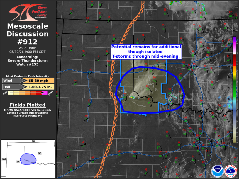
Mesoscale Discussion 0912 NWS Storm Prediction Center Norman OK 0653 PM CDT Sat May 30 2026 Areas affected...Southwest Oklahoma and adjacent portions of Texas Concerning...Severe Thunderstorm Watch 255... Valid 302353Z - 310200Z The severe weather threat for Severe Thunderstorm Watch 255 continues. SUMMARY...Thunderstorms have struggled to maintain intensity within a weakly forced, but otherwise favorable convective environment. While storm coverage and intensity are uncertain due to recent trends, additional thunderstorm development appears possible through mid-evening based on GOES imagery. DISCUSSION...A pair of supercells across the far eastern TX Panhandle have struggled to maintain intensity over the past hour with both cells largely dissipated as of 23:50 UTC. The lackluster sustenance of these cells is likely owing to weak forcing for ascent across the region as the primary upper-level trough axis shifts away from the region to the north. However, there are hints in recent GOES imagery that additional convection is possible in the coming hours. Low-level water-vapor imagery reveals a subtle ribbon of vorticity spreading east across the TX Panhandle towards the dryline, which may bolster ascent to some degree over the next hour. Some hints of this ascent are already noted as a few deeper congestus clouds develop along the dryline to the west of the weakening cells. Additionally, a cluster of elevated cumulus south of the Lawton, OK area has seen steady, albeit slow, growth over the past hour. Confidence is low that either of these regions will see substantial convective intensification, but recent RRFS solutions hint at isolated thunderstorms through roughly 04 UTC within an otherwise favorable convective environment. ..Moore.. 05/30/2026 ...Please see www.spc.noaa.gov for graphic product... ATTN...WFO...OUN...LUB...AMA... LAT...LON 34150051 34450071 34690067 35050044 35180031 35340005 35419973 35379911 35259860 35059822 34719798 34449789 34109798 33959824 33899870 33859906 33839980 33890039 34150051 MOST PROBABLE PEAK WIND GUST...65-80 MPH MOST PROBABLE PEAK HAIL SIZE...1.00-1.75 IN |
|
|
Top/All Mesoscale Discussions/Forecast Products/Home |
|
Source link