| Mesoscale Discussion 902 | |
| < Previous MD | |

|
|
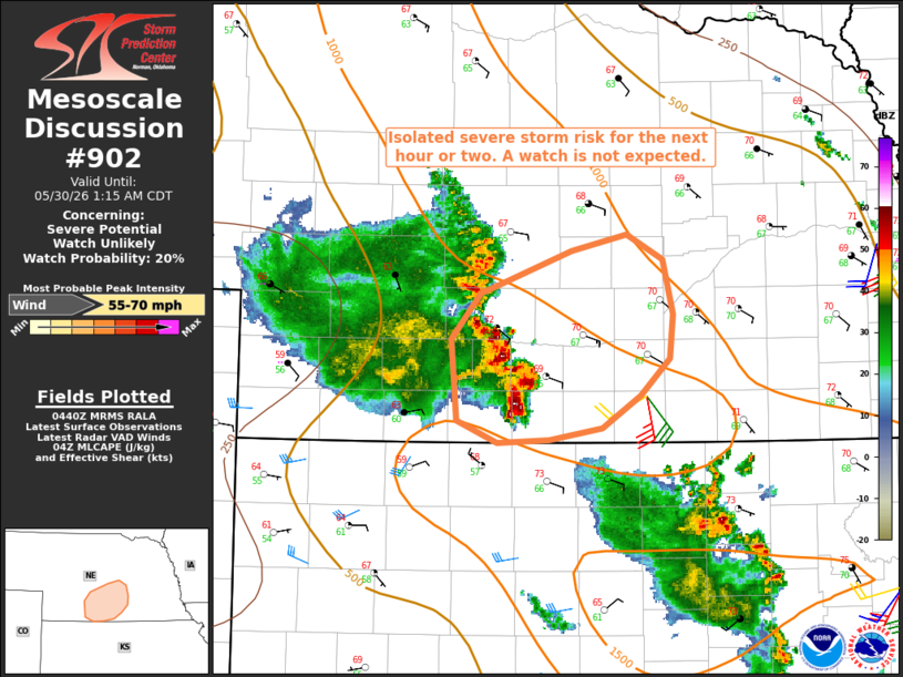
   Mesoscale Discussion 0902
   NWS Storm Prediction Center Norman OK
   1143 PM CDT Fri May 29 2026

   Areas affected...south-central Nebraska

   Concerning...Severe potential...Watch unlikely

   Valid 300443Z - 300615Z

   Probability of Watch Issuance...20 percent

   SUMMARY...The potential for locally severe wind gusts may persist
   for the next hour or two. A watch is currently not anticipated.

   DISCUSSION...As of 04:35 UTC, KUEX radar indicated the apex of a
   bowing line segment near Holdrege, with that feature indicating some
   forward-propagational characteristics. A wind gust of 67 mph was
   recently reported near Oxford. The downstream air mass across
   south-central NE is relatively moist with dewpoints in the mid 60s,
   which are contributing to MLCAPE of 1000-1500 J/kg. However,
   RAP-based forecast soundings and plan-view objective fields indicate
   poor low-level lapse rates, which are expected to temper the
   intensity of and areal extent of any severe wind gust threat.
   Nonetheless, the presence of an organized cold pool, and relatively
   strong storm-relative inflow into the convective system (ref.
   current KUEX VWP) may continue to support isolated occurrences of
   severe wind gusts for the next hour or two.

   Given the expected areal coverage of the severe-weather threat, a
   watch is not anticipated.

   ..Mead/Guyer.. 05/30/2026

   ...Please see www.spc.noaa.gov for graphic product...

   ATTN...WFO...GID...LBF...

   LAT...LON   40009975 40150012 40690016 41009991 41309909 41419861
               41239829 40869819 40579822 40329849 40099883 40019929
               40009975

   MOST PROBABLE PEAK WIND GUST...55-70 MPH
|
|
|
Top/All Mesoscale Discussions/Forecast Products/Home |
|
Source link