| Mesoscale Discussion 900 | |
| < Previous MD | |

|
|
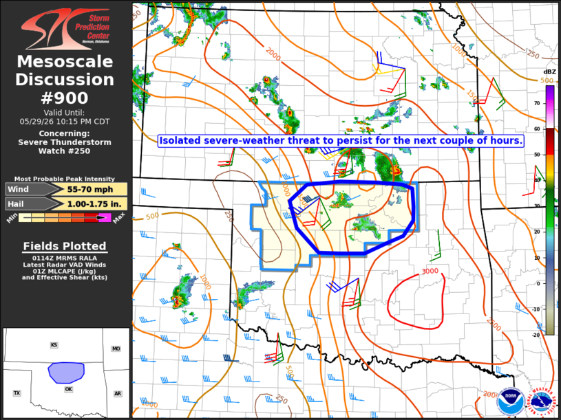
Mesoscale Discussion 0900 NWS Storm Prediction Center Norman OK 0816 PM CDT Fri May 29 2026 Areas affected...north-central Oklahoma Concerning...Severe Thunderstorm Watch 250... Valid 300116Z - 300315Z The severe weather threat for Severe Thunderstorm Watch 250 continues. SUMMARY...The potential for isolated occurrences of large hail and/or severe wind gusts will persist for the next couple of hours. DISCUSSION...As of 01:10 UTC, a series of small storms were located from southern Noble into Garfield and Grant Counties, to the north of an outflow boundary. It's unclear whether that convection is truly surface-based or slightly elevated. In either case, ample instability (see 00 UTC OUN sounding) persists within the inflow air mass. Both the KTLX and KVNX VWPs indicate a gradual increase in wind speed in the lowest 1.0-1.5 km AGL, a trend which is expected to continue through mid to late evening. A resultant increase in storm-relative inflow may support storm intensification with attendant risk for large hail and perhaps locally severe wind gusts for the next couple of hours. The current expectation is that the remaining valid portion of the watch will be allowed to expire at 03 UTC. ..Mead.. 05/30/2026 ...Please see www.spc.noaa.gov for graphic product... ATTN...WFO...TSA...ICT...OUN... LAT...LON 35939666 35769713 35759767 35769812 36209861 36669876 36969839 37019767 37009682 36959631 36889609 36579608 36329608 36069631 35939666 MOST PROBABLE PEAK WIND GUST...55-70 MPH MOST PROBABLE PEAK HAIL SIZE...1.00-1.75 IN |
|
|
Top/All Mesoscale Discussions/Forecast Products/Home |
|
Source link