| Mesoscale Discussion 888 | |
| < Previous MD | |

|
|
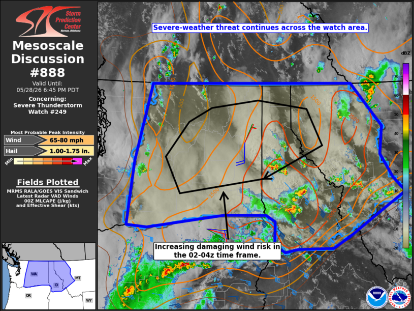
Mesoscale Discussion 0888 NWS Storm Prediction Center Norman OK 0742 PM CDT Thu May 28 2026 Areas affected...central and eastern Washington into the Idaho Panhandle and northwest Montana Concerning...Severe Thunderstorm Watch 249... Valid 290042Z - 290145Z The severe weather threat for Severe Thunderstorm Watch 249 continues. SUMMARY...The threat for large hail up to golf-ball size and locally severe wind gusts continues across the watch area. The potential for a more widespread damaging-wind event may evolve in the 02-04z time frame across parts of eastern WA and the northern ID Panhandle, possibly into far northwest MT, with gusts up to 70-75 mph. DISCUSSION...Recent visible satellite and radar data indicate robust thunderstorms ongoing across the central ID Panhandle, along and to the north of a surface boundary where steep lapse rates and dewpoints in the 50s to around 60 are yielding MLCAPE of 1500-2500+ J/kg. The instability coincides with steadily strengthening mid/upper-level winds and resultant vertical shear, with the parameter space supportive of supercell structures capable of large hail. Latest model guidance suggests that growing cold pools associated with the ID convection, and additional strong to severe storms ongoing across parts of northeast OR may consolidate, leading to a northward-accelerating thunderstorm line in the 02-04z time frame. The downstream air mass across central and eastern WA has become quite hot, with a deeply mixed boundary layer and DCAPE values of 1000-1500+ J/kg. Should the scenario unfold as the model guidance suggests, the ambient thermodynamic environment will favor strong to intense convective downdrafts capable of wind gusts up to 70-75 mph. ..Mead.. 05/29/2026 ...Please see www.spc.noaa.gov for graphic product... ATTN...WFO...TFX...MSO...BOI...OTX...PDT...SEW... LAT...LON 46001825 45682083 45722150 47192131 48972079 48991398 48001296 47361305 46821264 46491225 46101302 45481415 45221469 45221584 45141626 45301662 45851659 46011690 46001825 MOST PROBABLE PEAK WIND GUST...65-80 MPH MOST PROBABLE PEAK HAIL SIZE...1.00-1.75 IN |
|
|
Top/All Mesoscale Discussions/Forecast Products/Home |
|
Source link