| Mesoscale Discussion 868 | |
| < Previous MD | |
|
|
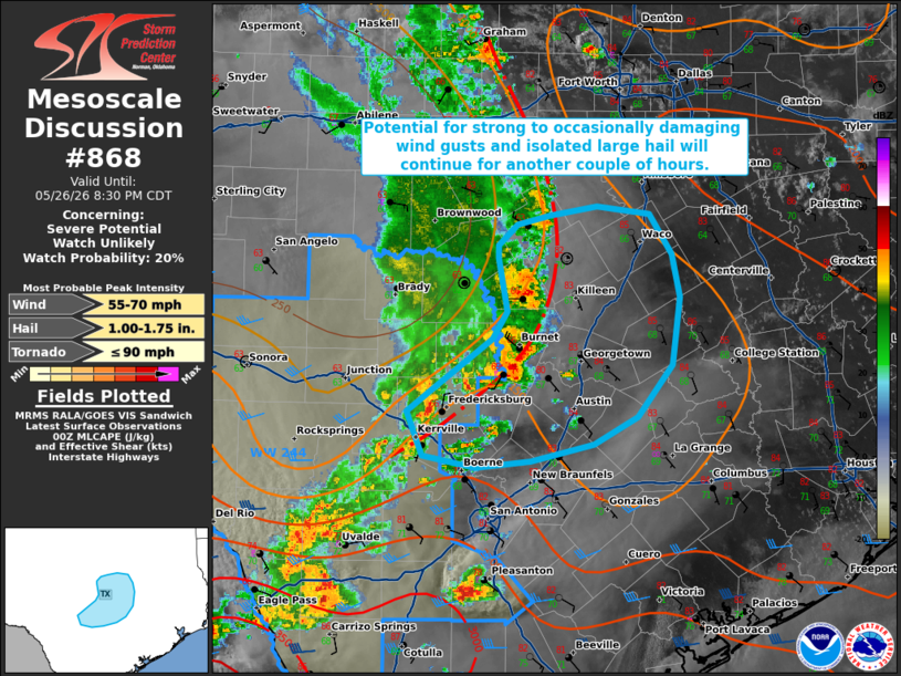
   Mesoscale Discussion 0868
   NWS Storm Prediction Center Norman OK
   0706 PM CDT Tue May 26 2026

   Areas affected...portions of central Texas

   Concerning...Severe potential...Watch unlikely

   Valid 270006Z - 270130Z

   Probability of Watch Issuance...20 percent

   SUMMARY...Potential for strong to occasionally damaging wind gusts
   and isolated large hail will continue for another 1-2 hours.
   Downstream watch issuance is unlikely, however.

   DISCUSSION...Latest radar imagery depicts the continued eastward
   propagation of a convective cluster across portions of central Texas
   as of 0000 UTC. The environment ahead of this activity remains
   modestly unstable (1000-1500 J/kg MLCAPE), but stronger upper-level
   flow and greater effective shear remain displaced farther to the
   south, with only 20-25 kts of effective shear analyzed across the
   discussion area. This is likely inhibiting the overall intensity and
   organization of this cluster, with radar data from KGRK indicating
   that the system outflow continues to largely precede the ongoing
   convection. Despite this, some potential for strong to occasionally
   damaging wind gusts may continue for another couple of hours.
   Isolated large hail may also be possible, particularly with any more
   robust, discrete convection that precedes this cluster. More limited
   mid-level lapse rates (generally less than 7 C/km) and the
   aforementioned modest effective shear should largely limit this
   potential, however. Trends will continue to be monitored, but
   downstream watch issuance is currently unlikely.

   ..Chalmers/Thompson.. 05/27/2026

   ...Please see www.spc.noaa.gov for graphic product...

   ATTN...WFO...HGX...FWD...EWX...

   LAT...LON   29899907 30249921 30429898 30799845 31009832 31419840
               31519840 31689824 31759795 31829752 31759705 31449685
               31119678 30609686 30199716 29989755 29859811 29819861
               29899907

   MOST PROBABLE PEAK TORNADO INTENSITY...UP TO 90 MPH
   MOST PROBABLE PEAK WIND GUST...55-70 MPH
   MOST PROBABLE PEAK HAIL SIZE...1.00-1.75 IN
|
|
|
Top/All Mesoscale Discussions/Forecast Products/Home |
|
Source link