| Mesoscale Discussion 867 | |
| < Previous MD | |
|
|
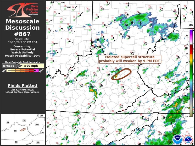
Mesoscale Discussion 0867 NWS Storm Prediction Center Norman OK 0656 PM CDT Tue May 26 2026 Areas affected...parts of east central Kentucky Concerning...Severe potential...Watch unlikely Valid 262356Z - 270130Z Probability of Watch Issuance...20 percent SUMMARY...Ongoing supercell structure now to the northeast of the Stanton vicinity seems likely to weaken by around 9 PM EDT. DISCUSSION...A sustained supercell structure has been maintained along a modest zone of differential surface heating to the north through northeast of Stanton KY the past hour or so. Deep-layer shear along this boundary appears rather marginal, and low-level hodographs, though exhibiting clockwise curvature, are rather small. However, near-surface buoyancy and potential upward parcel accelerations probably are being aided by a moist boundary-layer with dew points near 70F. Although this cell has probably produced one or two weak tornadoes, it is not clear that this will continue much longer, as the boundary-layer begins to stabilize with slow radiational surface cooling. ..Kerr/Thompson.. 05/26/2026 ...Please see www.spc.noaa.gov for graphic product... ATTN...WFO...RLX...JKL... LAT...LON 38258321 38148294 37888342 37918385 38258321 MOST PROBABLE PEAK TORNADO INTENSITY...UP TO 90 MPH |
|
|
Top/All Mesoscale Discussions/Forecast Products/Home |
|
Source link