| Mesoscale Discussion 863 | |
| < Previous MD | |

|
|
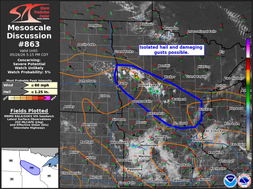
   Mesoscale Discussion 0863
   NWS Storm Prediction Center Norman OK
   0314 PM CDT Tue May 26 2026

   Areas affected...portions of north-central Minnesota

   Concerning...Severe potential...Watch unlikely

   Valid 262014Z - 262215Z

   Probability of Watch Issuance...5 percent

   SUMMARY...Scattered thunderstorms may pose a risk for isolated hail
   or damaging gusts. Storm organization will be limited and a WW is
   unlikely.

   DISCUSSION...As of 2010 UTC, regional visible and radar imagery
   showed towering cumulus and initial thunderstorms deepening along a
   frontal boundary across far eastern ND and north-central MN. Ample
   heating is supporting weak destabilization along and south of the
   frontal zone this afternoon. Deep-layer flow and effective shear are
   quite weak suggesting little in the way of storm organization. The
   multi cell storms amid relatively cool mid-level temperatures could
   support occasional severe hail with the stronger updrafts. The
   low-level air mass is also well-mixed with T/TD spread near 40
   degrees F. The dry low-level may allow for stronger gusts with the
   more robust downdrafts.

   Current expectations are for storms to gradually intensify along the
   front this afternoon. With little in the way of organization, the
   severe threat is likely to be sporadic/limited, but focused where
   any stronger storms can cluster and persist. Given the lack of
   broader support, a WW is unlikely at this time.

   ..Lyons/Gleason.. 05/26/2026

   ...Please see www.spc.noaa.gov for graphic product...

   ATTN...WFO...DLH...MPX...FGF...

   LAT...LON   47559687 47529609 46999427 46359276 45719280 45499311
               45459381 45589438 46039534 46639641 46969688 47199697
               47559687

   MOST PROBABLE PEAK WIND GUST...UP TO 60 MPH
   MOST PROBABLE PEAK HAIL SIZE...UP TO 1.25 IN
|
|
|
Top/All Mesoscale Discussions/Forecast Products/Home |
|
Source link