| Mesoscale Discussion 83 | |
| < Previous MD | |

|
|
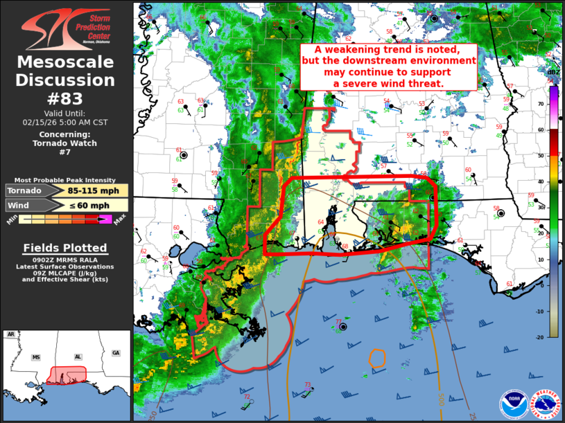
Mesoscale Discussion 0083 NWS Storm Prediction Center Norman OK 0304 AM CST Sun Feb 15 2026 Areas affected...Far southeast Mississippi into southern Alabama and the far western Florida Peninsula Concerning...Tornado Watch 7... Valid 150904Z - 151100Z The severe weather threat for Tornado Watch 7 continues. SUMMARY...A weakening trend has been noted with the QLCS exiting the lower Mississippi River Valley over the past two hours. While a lull in convective intensity is anticipated over the coming hours, the downstream environment could still support damaging to severe wind gusts in the near term. DISCUSSION...Diminishing lightning counts, warming cloud-top temperatures, and decreasing VIL values have all been observed over the past two hours with the QLCS traversing southeast LA and southern MS. The viable warm sector capable of support intense convection continues to become spatially confined closer to the coast where low to mid-60s dewpoints remain in place. Veering surface winds ahead of the line suggest low-level convergence is diminishing and is likely also contributing to the weakening trend in conjunction with limited buoyancy. However, the KMOB VWP continues to sample approximately 25 knots of 0-3 km BWD and around 40 knots of 0-6 km BWD ahead of the line. This, coupled with residual buoyancy along the coast, may continue to support sporadic damaging/severe winds across the remainder of WW 7. Recent HRRR solutions seem to support this idea and hint at more intense cells over the Gulf waters moving onshore through around 11 UTC that may pose a localized severe wind risk. ..Moore.. 02/15/2026 ...Please see www.spc.noaa.gov for graphic product... ATTN...WFO...TAE...MOB...LIX... LAT...LON 30508904 30768880 31198875 31318862 31358665 31318640 31208626 30648626 30458636 30388674 30298718 30238782 30258828 30248884 30248904 30508904 MOST PROBABLE PEAK TORNADO INTENSITY...85-115 MPH MOST PROBABLE PEAK WIND GUST...UP TO 60 MPH |
|
|
Top/All Mesoscale Discussions/Forecast Products/Home |
|
Source link