| Mesoscale Discussion 816 | |
| < Previous MD | |

|
|
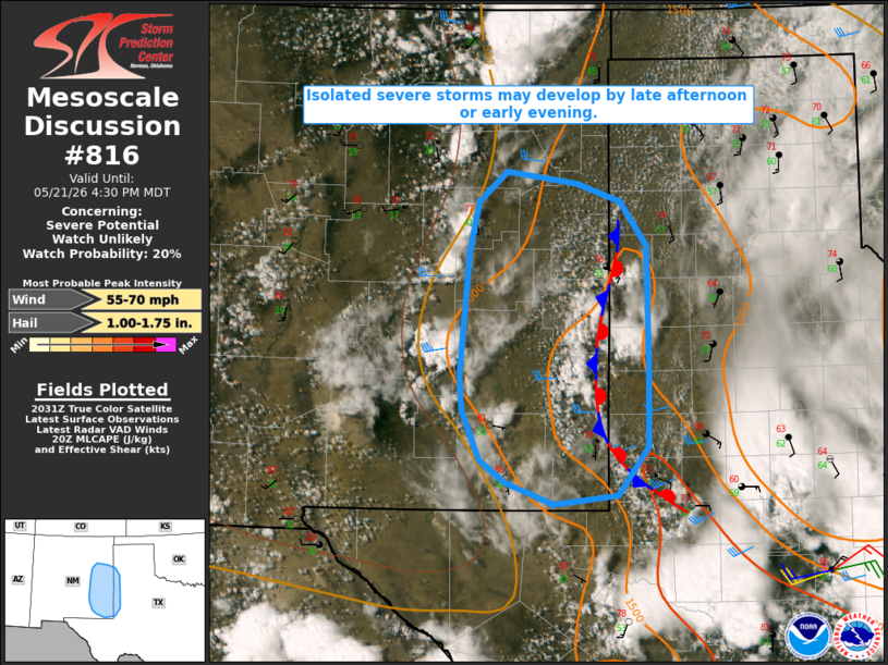
   Mesoscale Discussion 0816
   NWS Storm Prediction Center Norman OK
   0335 PM CDT Thu May 21 2026

   Areas affected...parts of eastern NM into adjacent west TX

   Concerning...Severe potential...Watch unlikely

   Valid 212035Z - 212230Z

   Probability of Watch Issuance...20 percent

   SUMMARY...Isolated severe storms may develop by late afternoon or
   early evening.

   DISCUSSION...Cumulus is increasing this afternoon near the higher
   terrain of east-central NM, and also in the vicinity of a baroclinic
   zone near the NM/TX border. With only weak to modest large-scale
   ascent across the region, coverage of storm development may remain
   relatively isolated. However, steep midlevel lapse rates and
   moderate buoyancy will conditionally support development of robust
   updrafts. Effective shear of 20-30 kt is only marginally supportive
   of organized convection, but organized multicells could eventually
   develop, and supercell or two cannot be ruled out near the
   baroclinic zone. Large hail and localized strong to severe gusts
   could accompany the strongest storms.

   ..Dean/Hart.. 05/21/2026

   ...Please see www.spc.noaa.gov for graphic product...

   ATTN...WFO...LUB...AMA...MAF...ABQ...

   LAT...LON   33320483 34560472 35080461 35370426 35250343 35070291
               34630260 34120258 33350257 32630258 32140295 32060370
               32270429 32490459 32990479 33320483

   MOST PROBABLE PEAK WIND GUST...55-70 MPH
   MOST PROBABLE PEAK HAIL SIZE...1.00-1.75 IN
|
|
|
Top/All Mesoscale Discussions/Forecast Products/Home |
|
Source link