| Mesoscale Discussion 809 | |
| < Previous MD | |
|
|
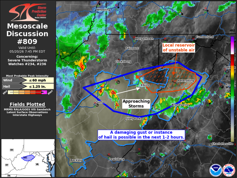
Mesoscale Discussion 0809 NWS Storm Prediction Center Norman OK 0614 PM CDT Wed May 20 2026 Areas affected...portions of northeast Virginia Concerning...Severe Thunderstorm Watch 234...236... Valid 202314Z - 202345Z The severe weather threat for Severe Thunderstorm Watch 234, 236 continues. SUMMARY...A damaging gust or episode of hail may occur in the next 1-2 hours. DISCUSSION...A cluster of storms continues to track northeast toward a localized a pristine airmass that has yet to be overturned by convection (e.g. the Grant County Airport ASOS showing 87 F surface temperatures). As such, storm cores in the area may remain strong enough over the next 1-2 hours to produce a damaging gust or instance of hail as they approach this reservoir of potentially unstable air. Thereafter, the severe threat should continue to diminish with time. ..Squitieri.. 05/20/2026 ...Please see www.spc.noaa.gov for graphic product... ATTN...WFO...LWX...PBZ...RLX... LAT...LON 38918094 39197983 39297910 39077864 38817882 38667916 38527953 38477985 38558035 38918094 MOST PROBABLE PEAK WIND GUST...UP TO 60 MPH MOST PROBABLE PEAK HAIL SIZE...UP TO 1.25 IN |
|
|
Top/All Mesoscale Discussions/Forecast Products/Home |
|
Source link