| Mesoscale Discussion 807 | |
| < Previous MD | |
|
|
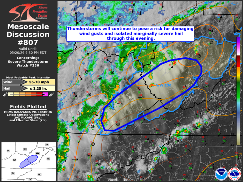
Mesoscale Discussion 0807 NWS Storm Prediction Center Norman OK 0355 PM CDT Wed May 20 2026 Areas affected...portions of eastern Kentucky into central West Virginia Concerning...Severe Thunderstorm Watch 236... Valid 202055Z - 202230Z The severe weather threat for Severe Thunderstorm Watch 236 continues. SUMMARY...The threat for damaging wind gusts continues across Severe Thunderstorm Watch 236. DISCUSSION...Latest radar imagery depicts several ongoing thunderstorm clusters from southern Kentucky northeastward into western/central West Virginia, with a couple of recent 1" hail reports noted north of Charleston, West Virginia. Continued diurnal heating has supported temperatures warming well into the 80s F across the region, which is subsequently contributing to 1000-1500 J/kg MLCAPE. Steep low-level lapse rates (exceeding 8 C/km per latest objective analysis) and dewpoint depressions of 20-25 F evident in recent surface observations continue to promote at least some potential for damaging wind gusts with ongoing thunderstorms. Modest effective shear (generally less than 30 kts) and weak mid-level lapse rates will largely temper the threat for large hail, but isolated small to marginally severe hail remains possible with the most robust cores. Expectation is for ongoing storms to persist into this evening before gradually dissipating owing to low-level nocturnal cooling/stabilization. ..Chalmers.. 05/20/2026 ...Please see www.spc.noaa.gov for graphic product... ATTN...WFO...RNK...RLX...MRX...JKL... LAT...LON 36968281 36698350 36698380 36948391 37278383 37618341 38018272 38448196 38548165 38598115 38548078 38368061 38198061 37888088 37728114 37278204 36968281 MOST PROBABLE PEAK WIND GUST...55-70 MPH MOST PROBABLE PEAK HAIL SIZE...UP TO 1.25 IN |
|
|
Top/All Mesoscale Discussions/Forecast Products/Home |
|
Source link