| Mesoscale Discussion 804 | |
| < Previous MD | |
|
|
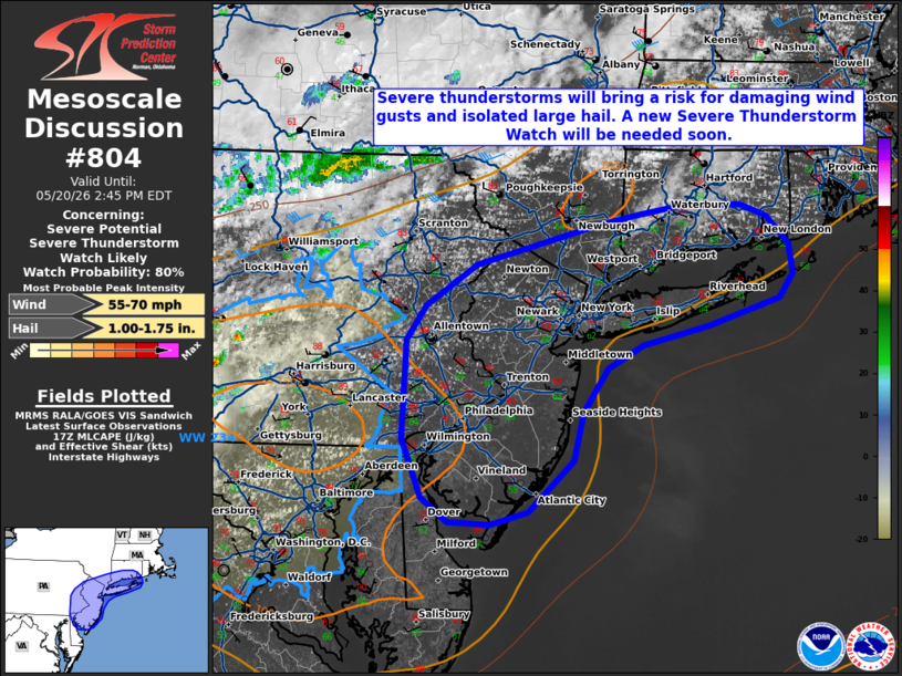
   Mesoscale Discussion 0804
   NWS Storm Prediction Center Norman OK
   1252 PM CDT Wed May 20 2026

   Areas affected...portions of the Mid-Atlantic into southern New
   England

   Concerning...Severe potential...Severe Thunderstorm Watch likely

   Valid 201752Z - 201845Z

   Probability of Watch Issuance...80 percent

   SUMMARY...Widely scattered thunderstorms will bring a risk for
   damaging wind gusts and isolated large hail through this evening. A
   Severe Thunderstorm Watch will be needed soon.

   DISCUSSION...Latest surface observations indicate that surface
   temperatures have warmed into the low 90s F across portion of the
   Mid-Atlantic. Coupled with mid-60s F dewpoints, this is supporting
   500-1000+ J/kg MLCAPE across the area, with further destabilization
   expected through peak heating this afternoon. Expectation is for
   ongoing thunderstorm activity across Severe Thunderstorm Watch 234
   to expand eastward, with additional development also possible along
   an approaching cold front. 20-30 kts of effective shear will support
   multicells, and perhaps marginal supercells. Steep low-level lapse
   rates (8+ C/km per latest objective analysis) and dewpoint
   depressions of 20-25+ F will promote the potential for damaging wind
   gusts, especially with any more well-organized clusters that
   develop. Isolated large hail may also accompany the most robust
   updrafts. A new Severe Thunderstorm Watch will be needed soon.

   ..Chalmers/Hart.. 05/20/2026

   ...Please see www.spc.noaa.gov for graphic product...

   ATTN...WFO...BOX...OKX...ALY...PHI...BGM...

   LAT...LON   40567574 40837554 41157502 41447382 41547334 41607289
               41607231 41517205 41297181 41077177 40877191 40667263
               40517332 40347368 39997393 39627403 39217449 39127488
               39147530 39327557 39787578 40567574

   MOST PROBABLE PEAK WIND GUST...55-70 MPH
   MOST PROBABLE PEAK HAIL SIZE...1.00-1.75 IN
|
|
|
Top/All Mesoscale Discussions/Forecast Products/Home |
|
Source link