| Mesoscale Discussion 802 | |
| < Previous MD Next MD > | |

|
|
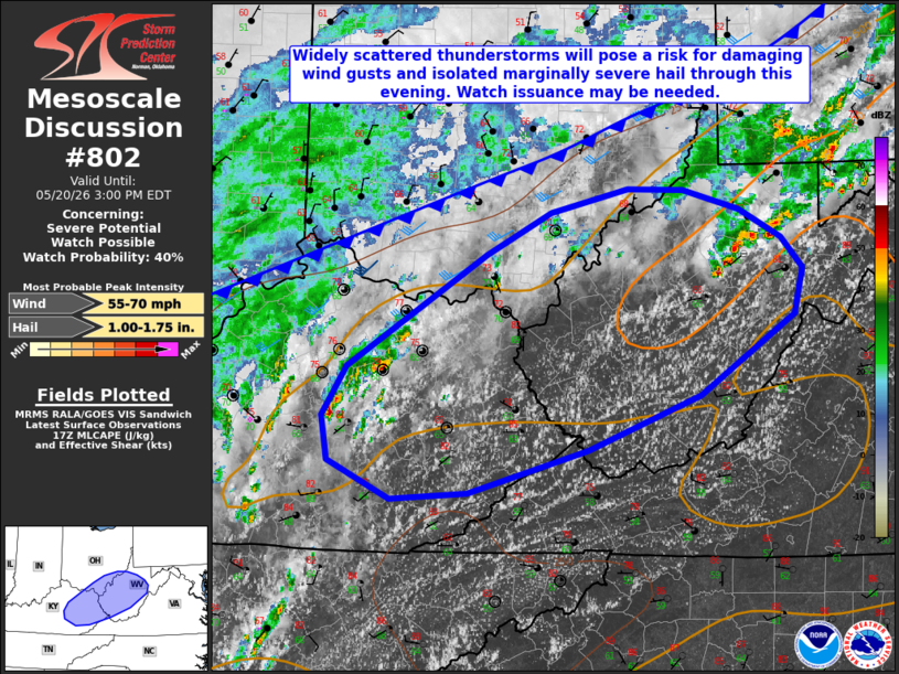
   Mesoscale Discussion 0802
   NWS Storm Prediction Center Norman OK
   1206 PM CDT Wed May 20 2026

   Areas affected...portions of the mid/upper Ohio Valley

   Concerning...Severe potential...Watch possible

   Valid 201706Z - 201900Z

   Probability of Watch Issuance...40 percent

   SUMMARY...Scattered thunderstorms will pose a risk for damaging wind
   gusts and isolated marginally severe hail through this evening. A
   Severe Thunderstorm Watch may be needed in the next 1-2 hours.

   DISCUSSION...Latest radar imagery and lightning data depict
   increasing thunderstorm coverage ahead of an approaching cold front
   across portions of the mid/upper Ohio Valley. Continued insolation
   has resulted in temperatures warming into the lower 80s F, with
   around 500 J/kg MLCAPE depicted via latest objective analysis.
   Continued diurnal heating is expected to result in further
   destabilization, with 500-1000+ J/kg MLCAPE expected by peak heating
   this afternoon. As convective inhibition continues to erode,
   expectation is for thunderstorm coverage to increase, with modest
   effective shear of 20-30 kts supporting multicells and perhaps
   marginal supercells.

   Steepening low-level lapse rates and dewpoint depressions of 20+ F
   will support damaging wind gusts as the primary hazard, especially
   with any clusters that can become better organized. Isolated
   marginally severe hail may also be possible with more robust
   updrafts despite only modest effective shear and weak mid-level
   lapse rates (as sampled by the 12z ILN observed sounding). While
   severe coverage/magnitude are expected to remain marginally more
   limited compared to areas farther east (e.g., the Mid-Atlantic), a
   Severe Thunderstorm Watch may be needed for a portion of the
   discussion area in the next 1-2 hours.

   ..Chalmers/Hart.. 05/20/2026

   ...Please see www.spc.noaa.gov for graphic product...

   ATTN...WFO...RNK...RLX...JKL...ILN...LMK...

   LAT...LON   38998292 39348225 39538147 39518089 39358032 39137988
               38887967 38507975 37858072 37418187 37078310 37028390
               37328453 37688459 38088434 38998292

   MOST PROBABLE PEAK WIND GUST...55-70 MPH
   MOST PROBABLE PEAK HAIL SIZE...1.00-1.75 IN
|
|
|
Top/All Mesoscale Discussions/Forecast Products/Home |
|
Source link