| Mesoscale Discussion 799 | |
| < Previous MD | |

|
|
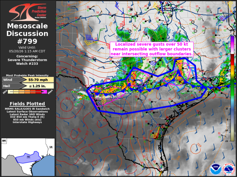
Mesoscale Discussion 0799 NWS Storm Prediction Center Norman OK 1150 PM CDT Tue May 19 2026 Areas affected...from the Laredo area eastward toward the middle to upper Texas Coast Concerning...Severe Thunderstorm Watch 233... Valid 200450Z - 200615Z The severe weather threat for Severe Thunderstorm Watch 233 continues. SUMMARY...Isolated wind gusts over 50 kt remain possible across parts of southern into southeast Texas, within the broader zone of 30-40 kt outflow. DISCUSSION...Within a broad W-E zone of thunderstorms, a few wind gusts over 50 kt have been measured, most recently at Kerrville TX with 56 kt. While most of the outflow as produced gusts of 30-40 kt, several larger/more organized storm clusters exist near intersecting outflow boundaries. The air mass remains quite moist, with modest southerly winds just above the surface aiding inflow (elevated above the outflow in some cases). At this time it appears the overall severe risk will remain isolated across the entire region, with most gusts below 50 kt. However, trends will continue to be monitored as the system as a whole develops southeastward tonight. ..Jewell.. 05/20/2026 ...Please see www.spc.noaa.gov for graphic product... ATTN...WFO...HGX...CRP...EWX... LAT...LON 29250098 29450070 29769915 29919899 30279875 30119827 29889757 30149683 30579672 30649625 30319577 29699572 29329524 28979551 28659687 28289928 28420044 28830073 29250098 MOST PROBABLE PEAK WIND GUST...55-70 MPH MOST PROBABLE PEAK HAIL SIZE...UP TO 1.25 IN |
|
|
Top/All Mesoscale Discussions/Forecast Products/Home |
|
Source link