| Mesoscale Discussion 795 | |
| < Previous MD | |

|
|
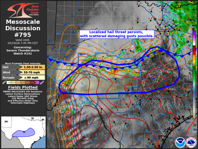
Mesoscale Discussion 0795 NWS Storm Prediction Center Norman OK 0548 PM CDT Tue May 19 2026 Areas affected...much of central Texas Concerning...Severe Thunderstorm Watch 232... Valid 192248Z - 200045Z The severe weather threat for Severe Thunderstorm Watch 232 continues. SUMMARY...Slow-moving cells continue to pose locally damaging hail and wind threat from the Trans-Pecos through the Hill Country. Additional areas east of WW 232 may eventually need to be in a watch. DISCUSSION...A very moist and unstable air mass exists south of the main cold front draped west-east across central TX. Severe storms remain ongoing from Sanderson to San Angelo, with new development along the front west of Waco TX. Given the slow movement of these storms, most of the activity should remain in WW 232, however, the new development east of the watch will likely need to be addressed as hail and locally severe downbursts may occur. Eventually, merging outflows will favor upscale growth into an MCS, with damaging wind potential spreading east/southeast. ..Jewell.. 05/19/2026 ...Please see www.spc.noaa.gov for graphic product... ATTN...WFO...HGX...FWD...EWX...SJT...MAF... LAT...LON 29790222 29830262 30050275 30250271 30600228 31020170 31340101 31290033 31149964 31209888 31479833 31899788 31979747 31779705 31329650 30829633 30539635 30209667 29869810 29770123 29790222 MOST PROBABLE PEAK TORNADO INTENSITY...UP TO 90 MPH MOST PROBABLE PEAK WIND GUST...55-70 MPH MOST PROBABLE PEAK HAIL SIZE...1.50-2.50 IN |
|
|
Top/All Mesoscale Discussions/Forecast Products/Home |
|
Source link