| Mesoscale Discussion 783 | |
| < Previous MD | |

|
|
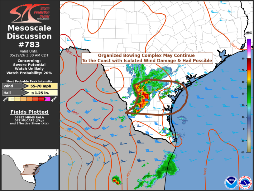
   Mesoscale Discussion 0783
   NWS Storm Prediction Center Norman OK
   0130 AM CDT Tue May 19 2026

   Areas affected...South Texas

   Concerning...Severe potential...Watch unlikely

   Valid 190630Z - 190830Z

   Probability of Watch Issuance...20 percent

   SUMMARY...A bowing complex of thunderstorms continues to move east
   across far south Texas. The environment ahead of the cluster remains
   extremely unstable. Strong winds and isolated hail may be possible
   with the core of these storms. A watch is currently not expected.

   DISCUSSION...An HP multicell cluster across northern Mexico has
   evolved into a small bowing cluster as it moves east across south
   Texas this morning. This complex appears to be aided by modest deep
   layer ascent in associated with a 70-knot 300-mb jet streak moving
   northeast from the base of the western North American longwave
   trough.

   The 20260519/00Z Corpus Christi sounding observed an extremely
   unstable airmass, with MUCAPE in excess of 4500 J/kg. Morning
   objectively analyzed fields suggest MUCAPE remains in excess of 4000
   J/kg. The observed sounding also sampled a very moist airmass, with
   precipitable water in excess of 2". Thus, heavy, water-laden
   downdrafts will support the possibility of damaging winds with this
   complex, despite the observed weak low-level lapse rates. Given the
   degree of instability, isolated hail cannot be ruled out.

   The limited spatial extent of this bowing complex (one storm only a
   couple of counties wide, rapidly approaching the coast) should
   preclude the need for a watch, although conditions will continue to
   be monitored.

   ..Marsh/Gleason.. 05/19/2026

   ...Please see www.spc.noaa.gov for graphic product...

   ATTN...WFO...CRP...BRO...

   LAT...LON   27149953 27419910 27829894 28109904 28319917 28569850
               28529780 28469715 28329681 28159665 27909659 27579668
               27289695 27119728 27059791 27149953

   MOST PROBABLE PEAK WIND GUST...55-70 MPH
   MOST PROBABLE PEAK HAIL SIZE...UP TO 1.25 IN
|
|
|
Top/All Mesoscale Discussions/Forecast Products/Home |
|
Source link