| Mesoscale Discussion 782 | |
| < Previous MD | |

|
|
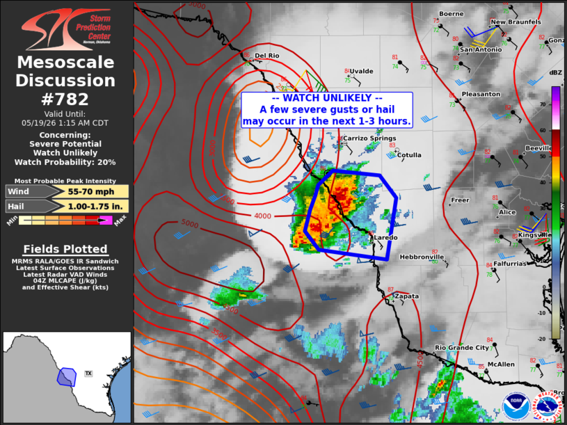
   Mesoscale Discussion 0782
   NWS Storm Prediction Center Norman OK
   1108 PM CDT Mon May 18 2026

   Areas affected...parts of far southern Texas/Laredo vicinity

   Concerning...Severe potential...Watch unlikely

   Valid 190408Z - 190615Z

   Probability of Watch Issuance...20 percent

   SUMMARY...Isolated severe gusts or hail may occur in the short term
   over far southern Texas toward the Rio Grande Valley. A watch is not
   currently anticipated.

   DISCUSSION...An extremely moist and unstable air mass exist over
   Deep South TX this evening, with MUCAPE approaching 5000 J/kg with
   mid to upper 70s F dewpoints and steep lapse rates aloft. A large
   cell on the Mexican side of the border persists, moving slowly east
   toward the Rio Grande. The core on that storm has generally
   weakened. However, new development is noted on the outflow/eastern
   flank of this cell, now into Webb County.

   Given the heavy precipitation/outflow, this complex may propagate
   southeastward at least for a couple hours. It is unclear whether
   this system will have further longevity tonight as inhibition
   increases. However, if the system continues to grow in size and/or
   accelerate without weakening, it could portend a severe wind threat
   farther southeast across the region. Trends will be monitored
   closely tonight.

   ..Jewell/Mosier.. 05/19/2026

   ...Please see www.spc.noaa.gov for graphic product...

   ATTN...WFO...CRP...EWX...

   LAT...LON   28080013 28249996 28199942 27969923 27339934 27430011
               27620027 27840021 27990015 28080013

   MOST PROBABLE PEAK WIND GUST...55-70 MPH
   MOST PROBABLE PEAK HAIL SIZE...1.00-1.75 IN
|
|
|
Top/All Mesoscale Discussions/Forecast Products/Home |
|
Source link