| Mesoscale Discussion 775 | |
| < Previous MD | |

|
|
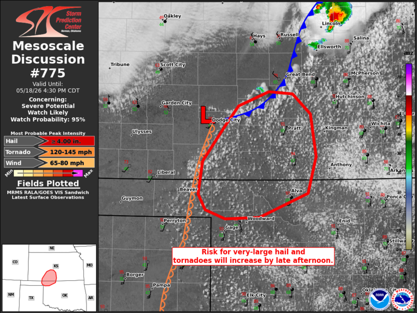
   Mesoscale Discussion 0775
   NWS Storm Prediction Center Norman OK
   0231 PM CDT Mon May 18 2026

   Areas affected...Northwest Oklahoma into Southwest Kansas

   Concerning...Severe potential...Watch likely

   Valid 181931Z - 182130Z

   Probability of Watch Issuance...95 percent

   SUMMARY...Large to very-large hail, severe winds, and tornadoes will
   be possible this afternoon. The degree of tornado/very-large hail
   threat will depend on a discrete storm mode. A watch is likely.

   DISCUSSION...Towering cumulus are increasing in the vicinity of
   Dodge City as convergence along a cold front has increased over the
   past couple of hours. With 40+ kt of effective shear and observed
   7.9 C/km mid-level lapse rate on the 18Z DDC sounding, initial
   supercells capable of very-large hail and severe winds can be
   expected. Tornadoes will also be possible where discrete modes can
   be maintained longer given the low-level shear. However, the linear
   forcing from the cold front may be enough to encourage a quick
   transition to a more linear mode. Regardless of the exact evolution,
   all severe hazards will be possible. A watch will likely be needed
   this afternoon.

   ..Wendt/Hart.. 05/18/2026

   ...Please see www.spc.noaa.gov for graphic product...

   ATTN...WFO...ICT...OUN...DDC...AMA...

   LAT...LON   36499920 36489977 36590009 36800021 37240015 37729977
               37999955 38189903 38149863 37889833 37319824 36819839
               36499920

   MOST PROBABLE PEAK TORNADO INTENSITY...120-145 MPH
   MOST PROBABLE PEAK WIND GUST...65-80 MPH
   MOST PROBABLE PEAK HAIL SIZE...4.00+ IN
|
|
|
Top/All Mesoscale Discussions/Forecast Products/Home |
|
Source link