| Mesoscale Discussion 772 | |
| < Previous MD Next MD > | |

|
|
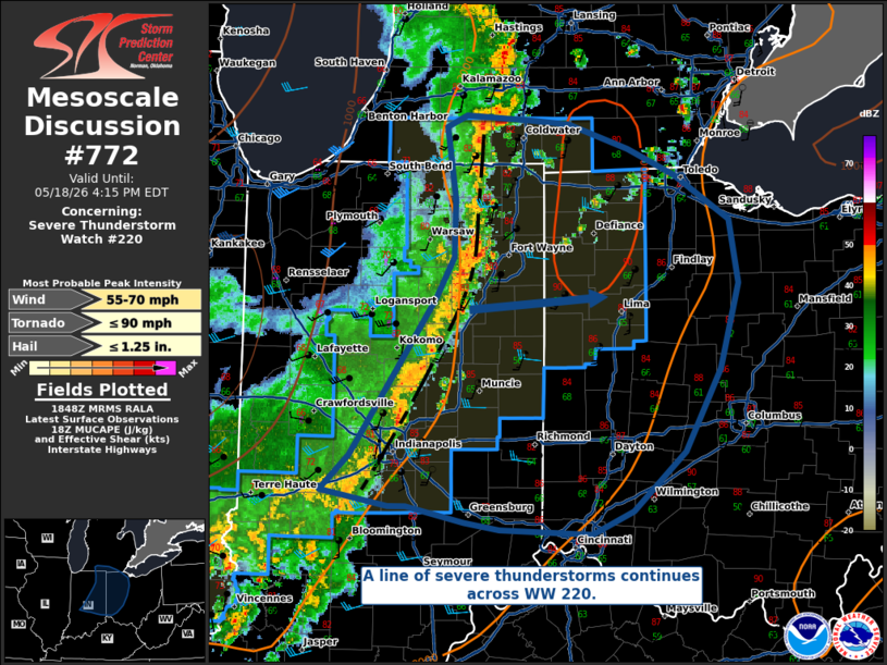
Mesoscale Discussion 0772 NWS Storm Prediction Center Norman OK 0150 PM CDT Mon May 18 2026 Areas affected...Western Indiana into Eastern Ohio Concerning...Severe Thunderstorm Watch 220... Valid 181850Z - 182015Z The severe weather threat for Severe Thunderstorm Watch 220 continues. SUMMARY...Severe thunderstorms persist and are progressing eastward across WW 220. They will continue to be capable of primarily damaging wind gusts. Conditions are being monitored for a new WW issued east of WW 220. DISCUSSION...A line of severe thunderstorms continues to progress across WW 220. Though the expectation is that the line should begin to weaken with eastward extent, it will still be capable of damaging wind gusts of 55-70 MPH within WW 220. Conditions will continue to be monitored for a new WW eastward into Ohio, though uncertainty exists in the convective longevity. Though the instability generally decreases with eastward extent, the well-established cold-pool could aid in persisting convection further east than the current WW 220 boundary. ..Halbert.. 05/18/2026 ...Please see www.spc.noaa.gov for graphic product... ATTN...WFO...CLE...ILN...DTX...IWX...GRR...IND... LAT...LON 39398604 39398620 39498680 39738654 40458605 40828578 41118562 41508561 42008568 42098551 42058498 42028458 41858403 41688362 41368311 40938303 40348321 39768352 39358400 39208437 39238519 39278552 39398604 MOST PROBABLE PEAK TORNADO INTENSITY...UP TO 90 MPH MOST PROBABLE PEAK WIND GUST...55-70 MPH MOST PROBABLE PEAK HAIL SIZE...UP TO 1.25 IN |
|
|
Top/All Mesoscale Discussions/Forecast Products/Home |
|
Source link