| Mesoscale Discussion 766 | |
| < Previous MD | |
|
|
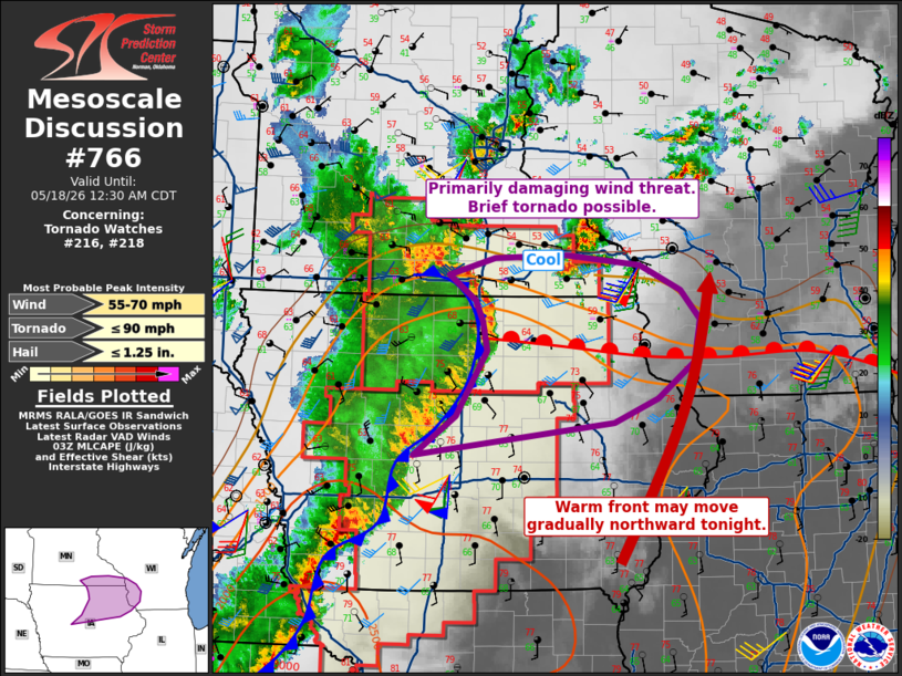
Mesoscale Discussion 0766 NWS Storm Prediction Center Norman OK 1032 PM CDT Sun May 17 2026 Areas affected...northeast Iowa into southwest Wisconsin Concerning...Tornado Watch 216...218... Valid 180332Z - 180530Z The severe weather threat for Tornado Watch 216, 218 continues. SUMMARY...Potential remains for damaging winds with the main line of storms. A brief tornado cannot be ruled out. DISCUSSION...A bow-echo is currently moving across north-central IA, with much of the push now north of the warm front. Recent surface observations indicate weaker wind gusts compared to earlier this evening as the cooler air is encountered. A warm front currently exists from this bow eastward into far southern WI. This boundary has not moved much, but may retreat northward overnight allow further destabilization into northeast IA and southwest WI. Given the 50 kt low-level jet, the surface cool layer immediately north of the warm front may become shallow enough to allow severe gusts to the surface. As such, the severe wind risk is expected to persist with the existing bow, and perhaps with additional waves that may form farther south along the squall line entering into central IA. An additional watch and/or extension may be needed into the remainder of eastern IA and into southwest WI in the coming hours. ..Jewell.. 05/18/2026 ...Please see www.spc.noaa.gov for graphic product... ATTN...WFO...MKX...DVN...ARX...MPX...DMX... LAT...LON 41919421 42309364 42969324 43259330 43469340 43719375 43889314 43919217 43809118 43569063 43269036 42859044 42499094 42259153 41919421 MOST PROBABLE PEAK TORNADO INTENSITY...UP TO 90 MPH MOST PROBABLE PEAK WIND GUST...55-70 MPH MOST PROBABLE PEAK HAIL SIZE...UP TO 1.25 IN |
|
|
Top/All Mesoscale Discussions/Forecast Products/Home |
|
Source link