| Mesoscale Discussion 763 | |
| < Previous MD | |

|
|
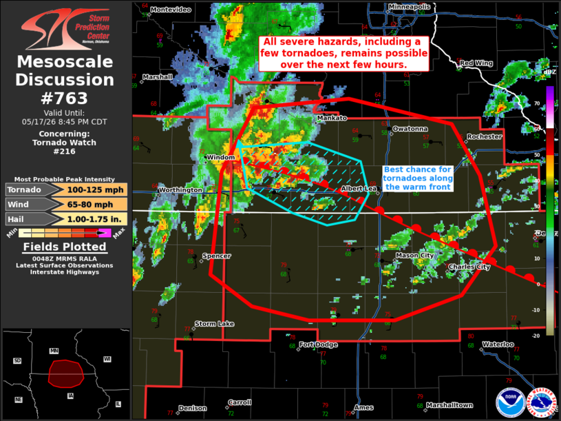
Mesoscale Discussion 0763 NWS Storm Prediction Center Norman OK 0749 PM CDT Sun May 17 2026 Areas affected...portions of northern Iowa into southern Minnesota Concerning...Tornado Watch 216... Valid 180049Z - 180145Z The severe weather threat for Tornado Watch 216 continues. SUMMARY...The threat for severe wind/hail and a few tornadoes continues with the stronger storms, particularly those along the warm front. DISCUSSION...Multicell clusters and supercell structures have developed ahead of an elongated QLCS, which have a history of hail, low-level rotation, and at least one brief tornado. These storms are showing strong rotation as they cross the warm front, where the best chance for tornadoes exists due to enhanced SRH in this region. The northern end of the QLCS will also approach from the southwest, accompanied by a severe wind/hail risk, though a line-embedded tornado cannot be ruled out with these storms as well. ..Squitieri.. 05/18/2026 ...Please see www.spc.noaa.gov for graphic product... ATTN...WFO...ARX...MPX...DMX...FSD... LAT...LON 43799495 44279463 44349366 44149260 43779233 43259218 42889252 42719319 42709405 42819463 43049504 43799495 MOST PROBABLE PEAK TORNADO INTENSITY...100-125 MPH MOST PROBABLE PEAK WIND GUST...65-80 MPH MOST PROBABLE PEAK HAIL SIZE...1.00-1.75 IN |
|
|
Top/All Mesoscale Discussions/Forecast Products/Home |
|
Source link