| Mesoscale Discussion 759 | |
| < Previous MD Next MD > | |

|
|
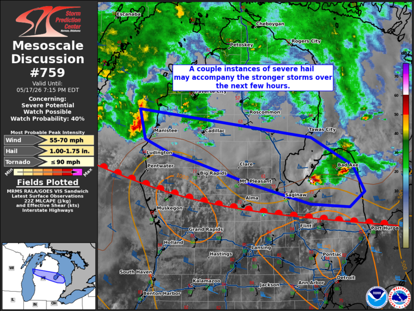
   Mesoscale Discussion 0759
   NWS Storm Prediction Center Norman OK
   0522 PM CDT Sun May 17 2026

   Areas affected...portions of central Lower Michigan

   Concerning...Severe potential...Watch possible

   Valid 172222Z - 172315Z

   Probability of Watch Issuance...40 percent

   SUMMARY...A few instances of severe hail may accompany multicells
   and isolated supercells over the next few hours.

   DISCUSSION...Widely scattered multicells and supercells continue to
   traverse a WAA regime to the north of a warm front. Given 50+ kts of
   effective bulk shear near these storms, severe hail may still occur
   with the strongest updrafts. Nonetheless, the severe threat is
   expected to be more on the sparse side. Conditions will continue to
   be monitored for the need of a WW issuance should storms experience
   a rapid trend in intensification, or become more widespread.

   ..Squitieri/Smith.. 05/17/2026

   ...Please see www.spc.noaa.gov for graphic product...

   ATTN...WFO...DTX...APX...GRR...

   LAT...LON   44578656 44208345 43848271 43508249 43308277 43348346
               43608453 43868549 43998598 44188645 44578656

   MOST PROBABLE PEAK TORNADO INTENSITY...UP TO 90 MPH
   MOST PROBABLE PEAK WIND GUST...55-70 MPH
   MOST PROBABLE PEAK HAIL SIZE...1.00-1.75 IN
|
|
|
Top/All Mesoscale Discussions/Forecast Products/Home |
|
Source link