| Mesoscale Discussion 754 | |
| < Previous MD Next MD > | |

|
|
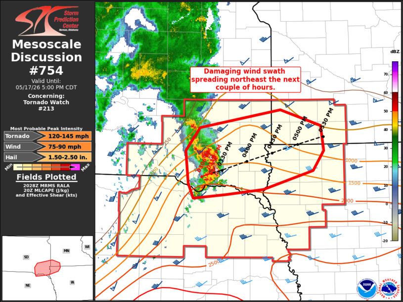
Mesoscale Discussion 0754 NWS Storm Prediction Center Norman OK 0331 PM CDT Sun May 17 2026 Areas affected...portions of southeast SD...far northwest IA...and far southwest MN Concerning...Tornado Watch 213... Valid 172031Z - 172200Z The severe weather threat for Tornado Watch 213 continues. SUMMARY...A swath of damaging winds up to 80 mph is possible downstream of an ongoing bow moving east/northeast across southeast SD this afternoon. DISCUSSION...A small but well-organized bow is ongoing across southeast South Dakota this afternoon. This storm has produced gusts near 80 mph over the past hour. The downstream environment remains favorable for a continuation of damaging wind swaths as convection moves along the gradient of moderate instability oriented across the region. Regional VWP data shows midlevel flow increasing to around 40-50 kt with rich low-level moisture in place across far southeast SD and northwest IA. Radar presentation recently suggests a rear-inflow jet may be developing, which aligns with strengthening midlevel flow noted in regional VWP. This supports a continued risk for strong to intense damaging winds to near 80 mph over the next 1-2 hours as the system continues east/northeast near 45-50 kt. ..Leitman.. 05/17/2026 ...Please see www.spc.noaa.gov for graphic product... ATTN...WFO...FSD...OAX... LAT...LON 43769797 44039626 43799540 43409534 43089557 42799662 42719741 42669810 42899822 43399827 43769797 MOST PROBABLE PEAK TORNADO INTENSITY...120-145 MPH MOST PROBABLE PEAK WIND GUST...75-90 MPH MOST PROBABLE PEAK HAIL SIZE...1.50-2.50 IN |
|
|
Top/All Mesoscale Discussions/Forecast Products/Home |
|
Source link