| Mesoscale Discussion 752 | |
| < Previous MD | |

|
|
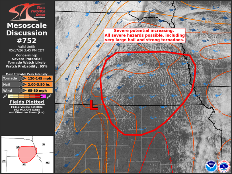
   Mesoscale Discussion 0752
   NWS Storm Prediction Center Norman OK
   0245 PM CDT Sun May 17 2026

   Areas affected...portions of south-central and southeast NE into
   north-central KS

   Concerning...Severe potential...Tornado Watch likely

   Valid 171945Z - 172045Z

   Probability of Watch Issuance...95 percent

   SUMMARY...The severe thunderstorm risk is increasing across portions
   of south-central and southeast Nebraska into north-central Kansas.
   All severe hazards are possible with storms that develop in the
   region, including very large hail and strong tornadoes. A tornado
   watch will likely be needed for portions of the MCD area soon.

   DISCUSSION...Strong heating and dewpoints climbing into the 66-69 F
   range beneath very steep midlevel lapse rates (as observed by 18z
   RAOB at OAX) is resulting in strong instability across the region.
   Latest visible satellite imagery shows an expanding cumulus field
   across the warm sector to the east of a dryline across central KS
   and into southern NE ahead of a southeastward-advancing cold front.
   The VWP at KUEX indicated 1-3 km flow around 30-40 kt with
   vertically veering wind profiles suggesting discrete supercells are
   possible within the open warm sector. This also is apparent in the
   last few WoFS runs, with most members of the ensemble forecast
   system indicating discrete supercell development. Confidence in this
   scenario is highest across NE where midlevel capping has largely
   eroded this afternoon. However, deepening cumulus and strong
   convergence near the surface low across north-central KS could
   support isolated development southward near the dryline/triple
   point.

   Given a very favorable thermodynamic and kinematic environment
   (especially as a low-level jet increases toward 00z), a tornado
   watch will likely be needed soon for portions of the MCD area.

   ..Leitman/Mosier.. 05/17/2026

   ...Please see www.spc.noaa.gov for graphic product...

   ATTN...WFO...EAX...OAX...TOP...ICT...GID...LBF...

   LAT...LON   41049965 41469944 41719901 41739690 41609585 41259560
               40839567 40459580 40049618 39459692 39209738 39039794
               39059865 39159883 39409918 40189959 40849968 41049965

   MOST PROBABLE PEAK TORNADO INTENSITY...120-145 MPH
   MOST PROBABLE PEAK WIND GUST...65-80 MPH
   MOST PROBABLE PEAK HAIL SIZE...2.00-3.50 IN
|
|
|
Top/All Mesoscale Discussions/Forecast Products/Home |
|
Source link