| Mesoscale Discussion 751 | |
| < Previous MD Next MD > | |

|
|
Mesoscale Discussion 0751
NWS Storm Prediction Center Norman OK
0232 PM CDT Sun May 17 2026
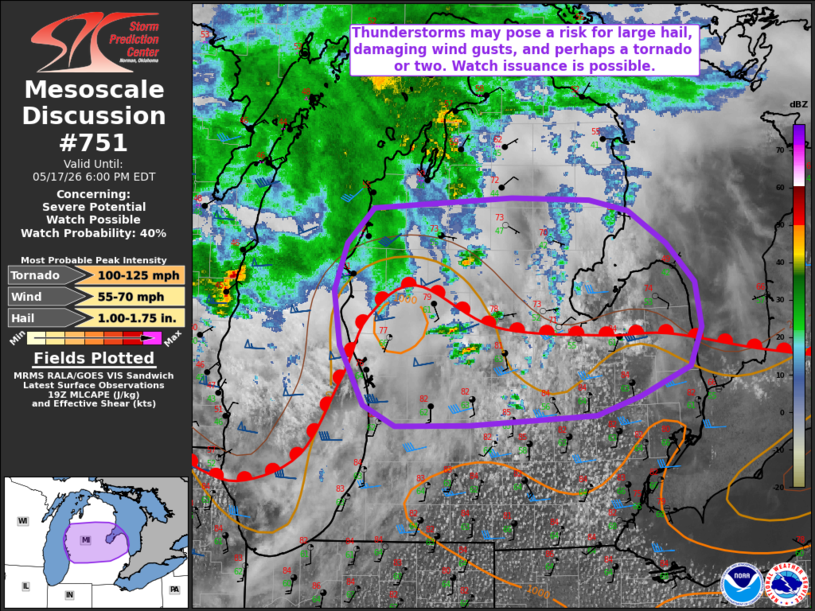
Areas affected...portions of central Lower Michigan
Concerning...Severe potential...Watch possible
Valid 171932Z - 172200Z
Probability of Watch Issuance...40 percent
SUMMARY...Thunderstorms may pose a risk for large hail and damaging
wind gusts, with some potential for a tornado or two. Watch issuance
is possible.
DISCUSSION...Latest GOES water vapor imagery reveals an MCV over
south-central Wisconsin, in close proximity to persistent elevated
convection that has been ongoing through the morning and into the
afternoon hours. Downstream of these features, latest surface
analysis indicates a quasi-stationary surface boundary/warm front
extending roughly west-east across central Lower Michigan with
recent convective development noted north of Grand Rapids. South of
this boundary, temperatures in the mid-80s and dewpoints in the low
60s F are contributing 500 to locally 1500 J/kg MLCAPE. 35-45 kts of
effective bulk shear (per latest mesoanalysis) is sufficient to
support multicells/supercells with any convection that develops
along/south of this boundary. This will promote the potential for
large hail and damaging wind gusts with any sustained convection
this afternoon.
With time, a strengthening southerly low-level jet is forecast to
yield an increase in low-level hodograph curvature into this
evening, which would favor at least some increase in the threat for
a tornado or two, particularly with any supercell/convection that
can favorably interact with the warm front. Uncertainty remains
regarding convective coverage and persistence within the warm
sector, however. Trends will continue to be monitored, and watch
issuance may eventually be needed.
..Chalmers/Mosier.. 05/17/2026
...Please see www.spc.noaa.gov for graphic product...
ATTN...WFO...DTX...APX...GRR...
LAT...LON 42718592 42888628 43378655 43828661 44218648 44508618
44588460 44578373 44478329 44208285 43898253 43528246
43198259 42958316 42808366 42728508 42718592
MOST PROBABLE PEAK TORNADO INTENSITY...100-125 MPH
MOST PROBABLE PEAK WIND GUST...55-70 MPH
MOST PROBABLE PEAK HAIL SIZE...1.00-1.75 IN
|
|
|
Top/All Mesoscale Discussions/Forecast Products/Home |
|
Source link