| Mesoscale Discussion 750 | |
| < Previous MD Next MD > | |

|
|
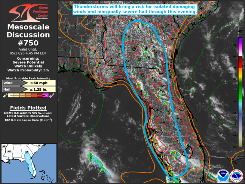
   Mesoscale Discussion 0750
   NWS Storm Prediction Center Norman OK
   0142 PM CDT Sun May 17 2026

   Areas affected...portions of the Florida Peninsula into North
   Florida and central Georgia

   Concerning...Severe potential...Watch unlikely

   Valid 171842Z - 172045Z

   Probability of Watch Issuance...5 percent

   SUMMARY...Widely scattered thunderstorms will pose a risk for
   isolated damaging wind gusts/downbursts and small to marginally
   severe hail through this evening. Watch issuance is not expected.

   DISCUSSION...An increase in convective coverage is expected through
   this afternoon from the western Florida Peninsula into southern
   Georgia along the Atlantic and Gulf Coast sea breezes. Temperatures
   in the low-90s F and dewpoints in the upper-60s to low-70s are
   supporting moderate to strong buoyancy, with MLCAPE of 2000-3000+
   J/kg analyzed per latest mesoanalysis. Despite moderately strong
   northwesterly upper-level flow, meager mid-level flow (less than 15
   kts sampled at 500 mb by the 12z TBW/JAX observed soundings) is
   forecast to limit effective bulk shear to around 20 kts or less.
   While this is expected to largely limit storm organization, a
   favorable thermodynamic environment should support pulse-severe type
   convection. Steep low-level lapse rates (8+ C/km) and PWAT values of
   1.5-1.8+ inches will promote the potential for strong to isolated
   damaging downburst winds (likely in the 45-55 mph range). Small to
   marginally severe hail may also accompany the strongest convective
   cores. Convection will largely be diurnally driven, with coverage
   forecast to decrease later this evening owing to nocturnal
   cooling/stabilization. Given the expectation for storm organization
   and threat magnitude to remain limited, watch issuance is not
   expected.

   ..Chalmers/Mosier.. 05/17/2026

   ...Please see www.spc.noaa.gov for graphic product...

   ATTN...WFO...MFL...MLB...TBW...JAX...FFC...TAE...

   LAT...LON   27988296 28448283 28868292 29168312 29558337 30138375
               30668391 31198400 31858406 32218392 32568369 32678330
               32658319 32548275 32168234 31808217 31478196 31118185
               30428179 29768173 29118160 28458146 27558119 26888093
               26408085 26118095 25988115 25868145 25898175 26248202
               27018253 27458277 27988296

   MOST PROBABLE PEAK WIND GUST...UP TO 60 MPH
   MOST PROBABLE PEAK HAIL SIZE...UP TO 1.25 IN
|
|
|
Top/All Mesoscale Discussions/Forecast Products/Home |
|
Source link