| Mesoscale Discussion 748 | |
| < Previous MD Next MD > | |

|
|
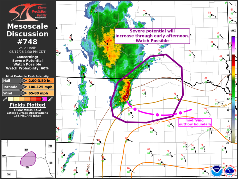
   Mesoscale Discussion 0748
   NWS Storm Prediction Center Norman OK
   1158 AM CDT Sun May 17 2026

   Areas affected...south-central SD into north-central NE

   Concerning...Severe potential...Watch possible

   Valid 171658Z - 171830Z

   Probability of Watch Issuance...60 percent

   SUMMARY...Severe thunderstorm potential will increase through early
   afternoon downstream from ongoing elevated convection across
   north-central Nebraska into south-central South Dakota. Area is
   being monitored for possible watch issuance.

   DISCUSSION...Elevated convection is ongoing at midday near the
   surface cold front. Inflow ahead of this storm complex is aiding in
   northwestward moisture transport across NE and near a modifying
   outflow boundary draped across north-central NE. With addition
   heating/moistening into early afternoon, convection developing along
   the southern flank of this storm complex may eventually become
   surface-based near the residual outflow boundary. Stronger
   destabilization is expected into the afternoon and this currently
   elevated activity may gradually become surface-based. Uncertainty
   remains regarding how this area of convection will ultimately evolve
   and how much severe potential will accompany this activity in the
   short term, before a more substantial risk develops further east
   later this afternoon. At least some large hail and damaging wind
   risk may accompany initial convection. Trends will be monitored and
   an initial watch issuance may be needed.

   ..Leitman/Mosier.. 05/17/2026

   ...Please see www.spc.noaa.gov for graphic product...

   ATTN...WFO...FSD...ABR...LBF...UNR...

   LAT...LON   42870114 43679978 43739910 43339845 42499842 41859885
               41659992 41670077 41850129 42260140 42870114

   MOST PROBABLE PEAK TORNADO INTENSITY...100-125 MPH
   MOST PROBABLE PEAK WIND GUST...65-80 MPH
   MOST PROBABLE PEAK HAIL SIZE...2.00-3.50 IN
|
|
|
Top/All Mesoscale Discussions/Forecast Products/Home |
|
Source link