| Mesoscale Discussion 747 | |
| < Previous MD | |

|
|
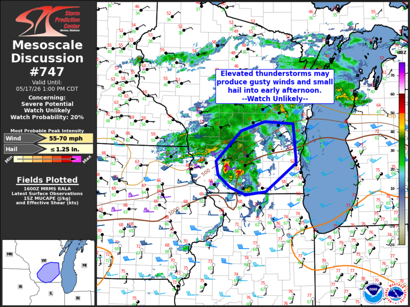
   Mesoscale Discussion 0747
   NWS Storm Prediction Center Norman OK
   1101 AM CDT Sun May 17 2026

   Areas affected...southern Wisconsin

   Concerning...Severe potential...Watch unlikely

   Valid 171601Z - 171800Z

   Probability of Watch Issuance...20 percent

   SUMMARY...Isolated elevated thunderstorms may produce small hail and
   locally strong wind gusts through early afternoon. A severe
   thunderstorm watch is not currently expected.

   DISCUSSION...Isolated thunderstorms are ongoing across southern WI
   this morning near a remnant MCV from overnight convection. This
   feature will continue to shift east/northeast into the afternoon.
   Meanwhile, a quasi-stationary boundary/warm front is located near
   the IL/WI border. Current convection remains north of this boundary
   within the cooler, more stable low-level environment. Nevertheless,
   modest moisture and enhanced vertical shear near the MCV is
   supporting weak MUCAPE and enough flow for organized updrafts.
   Midlevel lapse rates are weak across the region, though may steepen
   modestly into the afternoon. Given favorable deep layer shear and
   stronger midlevel flow, isolated strong gusts are possible in
   addition to small hail.

   ..Leitman/Mosier.. 05/17/2026

   ...Please see www.spc.noaa.gov for graphic product...

   ATTN...WFO...GRB...LOT...MKX...DVN...ARX...

   LAT...LON   43199038 43868964 44058894 44008810 43168802 42548892
               42478951 42638996 42899032 43199038

   MOST PROBABLE PEAK WIND GUST...55-70 MPH
   MOST PROBABLE PEAK HAIL SIZE...UP TO 1.25 IN
|
|
|
Top/All Mesoscale Discussions/Forecast Products/Home |
|
Source link