| Mesoscale Discussion 746 | |
| < Previous MD | |

|
|
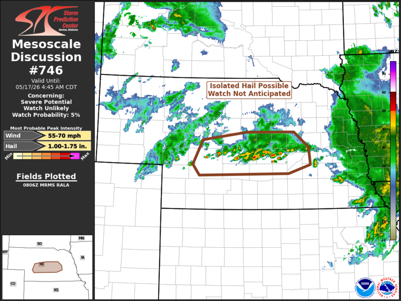
   Mesoscale Discussion 0746
   NWS Storm Prediction Center Norman OK
   0308 AM CDT Sun May 17 2026

   Areas affected...central Nebraska

   Concerning...Severe potential...Watch unlikely

   Valid 170808Z - 170945Z

   Probability of Watch Issuance...5 percent

   SUMMARY...Thunderstorms will continue to develop this morning across
   Nebraska. Although an isolated large hail report or two may occur,
   the overall trend should preclude the need for a watch.

   DISCUSSION...A west-to-east band of thunderstorms have developed
   this morning across central Nebraska in the wake of last evening's
   MCS. More specifically, these storms have developed within a
   warm-air advection (WAA)/isentropic ascent regime in the
   850-700-millibar layer ascending atop the outflow-modified boundary
   layer remnant from last evening's convection.

   These elevated thunderstorms will have access to MUCAPE around 1500
   J/kg and the strongest of the updrafts -- typically early in their
   lifecycle -- will be capable of producing hail. With time, the
   continued WAA should support a congealing of thunderstorm updrafts
   and a lessening of any severe potential. Thus, a watch is not
   anticipated.

   ..Marsh/Gleason.. 05/17/2026

   ...Please see www.spc.noaa.gov for graphic product...

   ATTN...WFO...OAX...GID...LBF...

   LAT...LON   41030113 41590083 41779949 41779807 41429762 41029757
               40829823 40790001 40770093 41030113

   MOST PROBABLE PEAK WIND GUST...55-70 MPH
   MOST PROBABLE PEAK HAIL SIZE...1.00-1.75 IN
|
|
|
Top/All Mesoscale Discussions/Forecast Products/Home |
|
Source link