| Mesoscale Discussion 744 | |
| < Previous MD | |

|
|
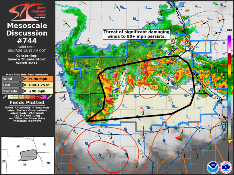
Mesoscale Discussion 0744 NWS Storm Prediction Center Norman OK 1015 PM CDT Sat May 16 2026 Areas affected...north-central into northeast Kansas and south-central into southeast Nebraska Concerning...Severe Thunderstorm Watch 211... Valid 170315Z - 170515Z The severe weather threat for Severe Thunderstorm Watch 211 continues. SUMMARY...The threat for significant damaging gusts of 70-85 mph persist this evening. DISCUSSION...A relatively compact but intense bow echo continues to produce significant severe gusts as it moves across northern KS and southern NE. Multiple gusts of 70-80+ mph have been measured over the past few hours, most recently 82 mph at Holdrege NE. Notably, these gusts have occurred even after cool northeast surface winds were seen at these stations. As such, at least the leading edge of the southward-moving outflow ahead of this bow does not appear to be mitigating severe potential. With a 50 kt low-level jet ahead of this activity and ample instability, the damaging wind threat is expected to persist across WW 211, possibly reaching the MO River later this evening. ..Jewell.. 05/17/2026 ...Please see www.spc.noaa.gov for graphic product... ATTN...WFO...OAX...TOP...GID...GLD... LAT...LON 39209971 39589911 39939906 40539931 40719901 41039696 41089636 40879600 40559583 40039577 39699594 39439663 39409701 39209971 MOST PROBABLE PEAK TORNADO INTENSITY...UP TO 90 MPH MOST PROBABLE PEAK WIND GUST...75-90 MPH MOST PROBABLE PEAK HAIL SIZE...1.00-1.75 IN |
|
|
Top/All Mesoscale Discussions/Forecast Products/Home |
|
Source link