| Mesoscale Discussion 742 | |
| < Previous MD Next MD > | |

|
|
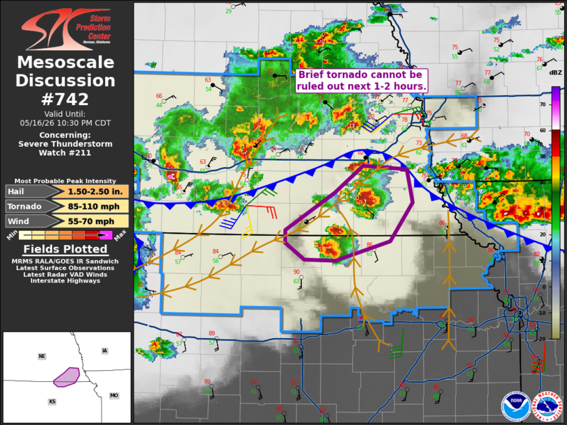
Mesoscale Discussion 0742 NWS Storm Prediction Center Norman OK 0836 PM CDT Sat May 16 2026 Areas affected...far southeast Nebraska toward far northeast Kansas Concerning...Severe Thunderstorm Watch 211... Valid 170136Z - 170330Z The severe weather threat for Severe Thunderstorm Watch 211 continues. SUMMARY...A brief tornado cannot be ruled out as cells interact with the wind shift/outflow. DISCUSSION...Several cells are currently ongoing from Washington County KS to just south of Lincoln, NE, and these are within the instability axis where MLCAPE is over 3000 J/kg. Surface analysis also shows an outflow boundary just north of these cells and extending into northwest MO, with a more subtle wind shift with northeast winds from just northwest of these cells into northern KS. Area VWPs show the increasing low-level jet with around 35 kt out of the south at Topeka. Given the increased shear with effective SRH now over 200 m2/s2, a brief period in time and space may exist for a brief tornado before these cells are undercut by the outflow. ..Jewell.. 05/17/2026 ...Please see www.spc.noaa.gov for graphic product... ATTN...WFO...OAX...TOP...GID... LAT...LON 40069787 40469718 40769678 40729615 40369608 39949640 39739717 39749761 39929787 40069787 MOST PROBABLE PEAK TORNADO INTENSITY...85-110 MPH MOST PROBABLE PEAK WIND GUST...55-70 MPH MOST PROBABLE PEAK HAIL SIZE...1.50-2.50 IN |
|
|
Top/All Mesoscale Discussions/Forecast Products/Home |
|
Source link