| Mesoscale Discussion 731 | |
| < Previous MD Next MD > | |

|
|
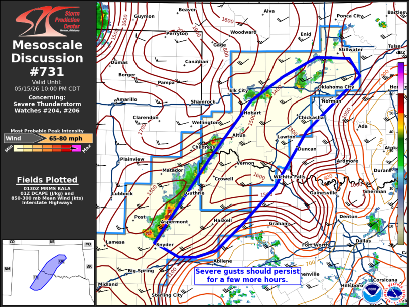
Mesoscale Discussion 0731 NWS Storm Prediction Center Norman OK 0833 PM CDT Fri May 15 2026 Areas affected...portions of western Oklahoma into northwestern Texas Concerning...Severe Thunderstorm Watch 204...206... Valid 160133Z - 160300Z The severe weather threat for Severe Thunderstorm Watch 204, 206 continues. SUMMARY...A few more severe gusts may occur with ongoing storms before nocturnal cooling weakens thunderstorms. DISCUSSION...A broken line of storms persists across western and central OK into northwestern TX. Despite the onset of nocturnal cooling, a few severe gusts have been reported in the past hour over northwestern TX. Given a residual mixed boundary layer and over 1000 J/kg DCAPE, along with 9+ C/km mid-level lapse rates (per 00Z OUN observed sounding) evaporative cooling potential with the stronger storm cores may foster severe gust potential for at least a couple more hours. Some of the latest runs of the WoFS depict severe gusts continuing into central OK over the next few hours. ..Squitieri.. 05/16/2026 ...Please see www.spc.noaa.gov for graphic product... ATTN...WFO...TSA...FWD...OUN...SJT...LUB...MAF... LAT...LON 32800092 34259983 35309893 35729824 36059752 36029683 35709661 34769776 33779845 33159912 32699965 32570007 32560042 32800092 MOST PROBABLE PEAK WIND GUST...65-80 MPH |
|
|
Top/All Mesoscale Discussions/Forecast Products/Home |
|
Source link