| Mesoscale Discussion 725 | |
| < Previous MD | |

|
|
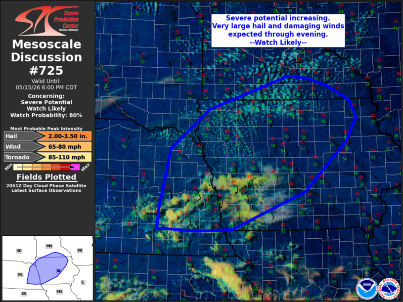
   Mesoscale Discussion 0725
   NWS Storm Prediction Center Norman OK
   0355 PM CDT Fri May 15 2026

   Areas affected...portions of eastern NE into western/central
   IA...and southern MN

   Concerning...Severe potential...Watch likely

   Valid 152055Z - 152300Z

   Probability of Watch Issuance...80 percent

   SUMMARY...Severe thunderstorm potential is increasing this
   afternoon, and convective initiation is expected over the next
   couple of hours. Large hail to 3 inches diameter, scattered damaging
   wind gusts, and a tornado or two will be possible through evening.
   Watch issuance is likely.

   DISCUSSION...Boundary layer moisture continue to spread northward
   this afternoon across the Mid-MO Valley, with dewpoints in the low
   60s F now across southeast NE and southwest IA. Strong heating into
   the mid 80s to low 90s amid steep midlevel lapse rates near 8.5 C/km
   per 18z region RAOBs is contributing to weak to moderate
   destabilization across the region. Deepening cumulus is noted ahead
   of a surface front across northeast NE into northwest IA and
   southern MN. Further south, midlevel cumulus atop a capping
   inversion is also deepening. This suggests large-scale ascent is
   increasing and beginning to overspread the area. Thunderstorm
   initiation is expected within the next couple of hours.

   Effective shear greater than 40 kt across the region and vertically
   veering wind profiles suggests initial development will rapidly
   organize and a few supercells are possible. Given very steep lapse
   rates and moderate to strong instability, large to very large hail
   is possible with this initial activity. Steep low-level lapse rates
   and modest boundary layer moisture will also support damaging gusts.

   With time, convection is expected to grow upscale into a more
   linear/forward-propagating storm mode as a low-level jet increases
   this evening and the surface front begins to shift southeast. This
   will support a swath of damaging gusts across portions of MN/IA this
   evening. Given supercell wind profiles and potential for a bowing
   MCS, a tornado or two also is possible later this evening as the
   low-level jet increases.

   ..Leitman/Guyer.. 05/15/2026

   ...Please see www.spc.noaa.gov for graphic product...

   ATTN...WFO...DVN...ARX...MPX...DMX...FSD...OAX...GID...

   LAT...LON   41009767 42409735 43279621 44039380 43989321 43809261
               43489195 43099173 42539206 41429333 40609548 40559648
               40609771 41009767

   MOST PROBABLE PEAK TORNADO INTENSITY...85-110 MPH
   MOST PROBABLE PEAK WIND GUST...65-80 MPH
   MOST PROBABLE PEAK HAIL SIZE...2.00-3.50 IN
|
|
|
Top/All Mesoscale Discussions/Forecast Products/Home |
|
Source link