| Mesoscale Discussion 723 | |
| < Previous MD | |

|
|
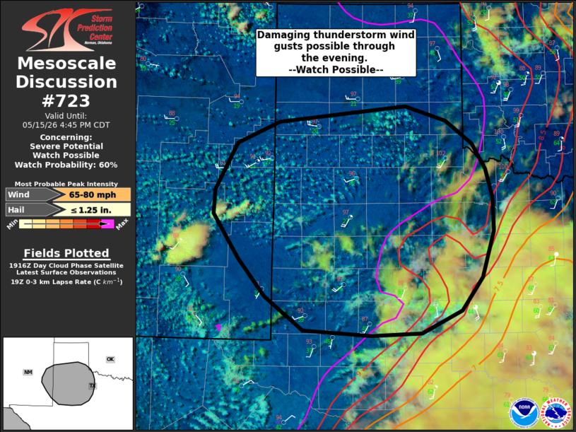
   Mesoscale Discussion 0723
   NWS Storm Prediction Center Norman OK
   0220 PM CDT Fri May 15 2026

   Areas affected...far eastern NM into the TX South Plains

   Concerning...Severe potential...Watch possible

   Valid 151920Z - 152145Z

   Probability of Watch Issuance...60 percent

   SUMMARY...Isolated thunderstorm development is expected over the
   next few hours. Strong to severe wind gusts are possible through the
   evening. A severe thunderstorm watch may be needed.

   DISCUSSION...An isolated thunderstorm has developed across southeast
   NM this afternoon while deepening cumulus continue to develop
   eastward into the TX South Plains vicinity as a weak upper shortwave
   trough ejects across the southern Rockies. A hot, dry and deeply
   mixed boundary layer is evident behind the dryline where
   temperatures are well into the 90s and dewpoints are in the 20s and
   30s. High-based convection developing within this airmass will pose
   a risk of strong wind gusts. With time and eastward extent toward
   western North TX, convection may increase in intensity as it emerges
   into somewhat increased low-level moisture east of the dryline where
   dewpoints are in the 40s and 50s and modest destabilization is
   occurring closer to the dryline. Convective trends are being
   monitored and a severe thunderstorm watch may be needed at some
   point this afternoon, though timing is a bit uncertain.

   ..Leitman/Guyer.. 05/15/2026

   ...Please see www.spc.noaa.gov for graphic product...

   ATTN...WFO...OUN...SJT...LUB...AMA...MAF...ABQ...

   LAT...LON   34630364 34920295 35130093 34930027 34629986 34289965
               33899953 33449952 32839971 32380004 32090068 32060148
               32130257 32580317 33090361 33680401 34000399 34630364

   MOST PROBABLE PEAK WIND GUST...65-80 MPH
   MOST PROBABLE PEAK HAIL SIZE...UP TO 1.25 IN
|
|
|
Top/All Mesoscale Discussions/Forecast Products/Home |
|
Source link