| Mesoscale Discussion 64 | |
| < Previous MD | |

|
|
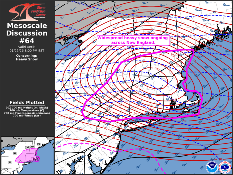
   Mesoscale Discussion 0064
   NWS Storm Prediction Center Norman OK
   0302 PM CST Sun Jan 25 2026

   Areas affected...northeast Pennsylvania and southeast New York into
   New England

   Concerning...Heavy snow

   Valid 252102Z - 260100Z

   SUMMARY...Heavy snow will continue from northeast Pennsylvania to
   New England this afternoon and into the evening.

   DISCUSSION...Widespread heavy snow is ongoing across the the
   Northeast and will continue into the evening. Numerous 6 hour
   snowfall amounts of 8-9 inches have been received from Long Island
   to Connecticut, supporting a mean snowfall rate of 1.5 inches per
   hour. Given radar intensity trends, much of this likely came in the
   last 3-4 hours, suggesting snowfall rates near 2 inches per hour are
   likely ongoing. Expect these extreme rates to continue for another 3
   to 4 hours from Connecticut to Massachusetts as frontogenesis
   continues northeastward across New England. Thereafter, continued
   heavy snow around 1 inch per hour may continue through the evening
   as the deformation band pivots across the region.

   ..Bentley.. 01/25/2026

   ...Please see www.spc.noaa.gov for graphic product...

   ATTN...WFO...GYX...BOX...BTV...OKX...ALY...PHI...BGM...

   LAT...LON   41236997 41087139 41117322 41007414 40957456 41077581
               41287597 41667582 42487471 43257398 43507306 43687185
               43747061 43717017 43577015 42987054 42587054 42437075
               42207064 42137039 42137008 42006986 41806976 41526988
               41236997
|
|
|
Top/All Mesoscale Discussions/Forecast Products/Home |
|
Source link