| Mesoscale Discussion 620 | |
| < Previous MD | |

|
|
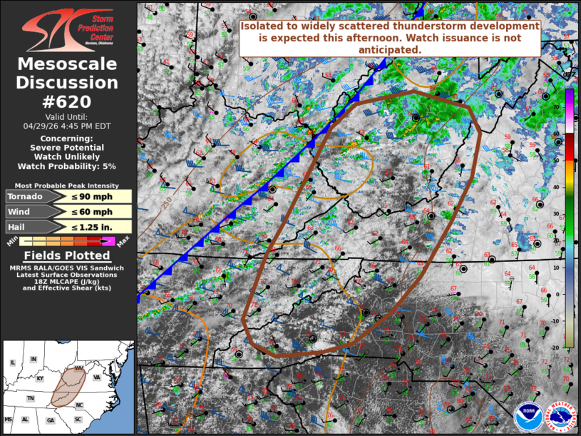
   Mesoscale Discussion 0620
   NWS Storm Prediction Center Norman OK
   0145 PM CDT Wed Apr 29 2026

   Areas affected...portions of the central/southern Appalachians into
   the Mid-Atlantic

   Concerning...Severe potential...Watch unlikely

   Valid 291845Z - 292045Z

   Probability of Watch Issuance...5 percent

   SUMMARY...Isolated to widely scattered thunderstorm development is
   expected this afternoon along/ahead of an approach cold front. A
   couple of stronger storms may pose an isolated risk for marginally
   severe hail, strong wind gusts, and a brief tornado. Watch issuance
   is not anticipated at this time.

   DISCUSSION...Latest regional radar imagery has shown transient
   strengthening of ongoing convective cores in the vicinity of
   Charleston, West Virginia, over the past 30-60 minutes. Latest
   high-res guidance continues to suggest additional development is
   likely across the northern Cumberland and central/southern Blue
   Ridge Mountains through the afternoon ahead of an approaching cold
   front. Continued diurnal heating amid scattered cloud cover and
   dewpoints in the upper-50s to lower-60s F are expected to promote
   marginally greater buoyancy compared to areas farther north, with
   latest forecast soundings indicating the presence of 500-1000 J/kg
   MLCAPE by later this afternoon. Elongated hodographs and 35-45+ kts
   of effective bulk shear amid strong flow aloft will support the
   potential for marginally severe hail with any stronger convective
   cores. Isolated strong wind gusts will also be possible given the
   presence of drier mid-level air, and a brief tornado cannot be ruled
   out given modest low-level hodograph curvature evident in regional
   VWPs. Watch issuance is not anticipated at this time given the
   overall expectation for limited threat coverage and magnitude.

   ..Chalmers/Smith.. 04/29/2026

   ...Please see www.spc.noaa.gov for graphic product...

   ATTN...WFO...LWX...RNK...RLX...GSP...MRX...JKL...

   LAT...LON   36358060 35818114 35378183 35238239 35178321 35348363
               35698381 36658340 37128310 38498226 38858179 39048070
               38787968 38417948 37777965 37118005 36358060

   MOST PROBABLE PEAK TORNADO INTENSITY...UP TO 90 MPH
   MOST PROBABLE PEAK WIND GUST...UP TO 60 MPH
   MOST PROBABLE PEAK HAIL SIZE...UP TO 1.25 IN
|
|
|
Top/All Mesoscale Discussions/Forecast Products/Home |
|
Source link