| Mesoscale Discussion 62 | |
| < Previous MD | |

|
|
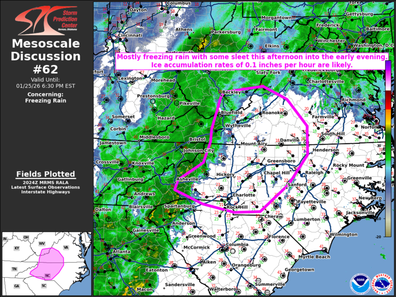
   Mesoscale Discussion 0062
   NWS Storm Prediction Center Norman OK
   0227 PM CST Sun Jan 25 2026

   Areas affected...western North Carolina and southwest Virginia

   Concerning...Freezing rain

   Valid 252027Z - 252330Z

   SUMMARY...Mostly freezing rain with some sleet expected this
   afternoon into the early evening.

   DISCUSSION...Temperatures remain in the upper teens to low 20s in
   the lee of the Appalachians this afternoon in the well-established
   wedge front. Some modification of this airmass has occurred and
   thus, forecast soundings appear more favorable for freezing rain
   than sleet this afternoon into this evening. Therefore, expect some
   additional ice accumulation over the next 3 to 4 hours as a
   stratiform precipitation shield expands across western North
   Carolina and southwest Virginia. Ice accretion rates of 0.1 inch per
   hour are likely where freezing rain falls.

   ..Bentley.. 01/25/2026

   ...Please see www.spc.noaa.gov for graphic product...

   ATTN...WFO...AKQ...RAH...RNK...RLX...CAE...GSP...

   LAT...LON   37017851 36297852 35577910 34907998 34888076 35088170
               35418257 35678247 36108170 36628150 36948146 37388131
               37728120 37868110 38017988 37677913 37017851
|
|
|
Top/All Mesoscale Discussions/Forecast Products/Home |
|
Source link