| Mesoscale Discussion 619 | |
| < Previous MD Next MD > | |

|
|
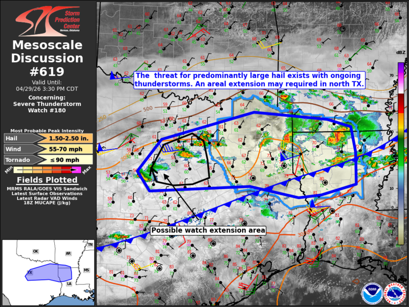
Mesoscale Discussion 0619 NWS Storm Prediction Center Norman OK 0137 PM CDT Wed Apr 29 2026 Areas affected...north Texas into the ArkLaTex Concerning...Severe Thunderstorm Watch 180... Valid 291837Z - 292030Z The severe weather threat for Severe Thunderstorm Watch 180 continues. SUMMARY...Large hail remains the predominant severe-weather threat in the near term. The hail threat is developing to the west of the current watch across portions of north Texas, and a local extension in area may be need. DISCUSSION...As of 1925z, mosaic radar data showed a broad zone of elevated thunderstorms extending from the Brownwood, TX vicinity into the ArkLaTex region. The most intense storms were located over Cass and Marion Counties in northeast TX, and Claiborne Parish in northwest LA with recent reports of 1.0-1.5" diameter hail with those storms. Modest low-level warm advection atop a stable, near-surface layer (per KFWD VWP) will continue to sustain the ongoing storms within a moderately unstable and strongly sheared environment. As such, the setup will remain favorable for embedded supercell structures capable of large hail up to 2.5" in diameter. The large-hail threat may materialize to the west of the current watch area, and a local extension may be required. Given the relatively closer proximity of the northwest LA storms to the surface front, the threat for severe wind gusts may increase as that activity continues southeast toward the boundary. ..Mead.. 04/29/2026 ...Please see www.spc.noaa.gov for graphic product... ATTN...WFO...SHV...FWD... LAT...LON 31999864 32819794 33529518 33329299 33139229 32489216 31679217 31429321 31369388 31669530 31509825 31999864 MOST PROBABLE PEAK TORNADO INTENSITY...UP TO 90 MPH MOST PROBABLE PEAK WIND GUST...55-70 MPH MOST PROBABLE PEAK HAIL SIZE...1.50-2.50 IN |
|
|
Top/All Mesoscale Discussions/Forecast Products/Home |
|
Source link