| Mesoscale Discussion 59 | |
| < Previous MD | |

|
|
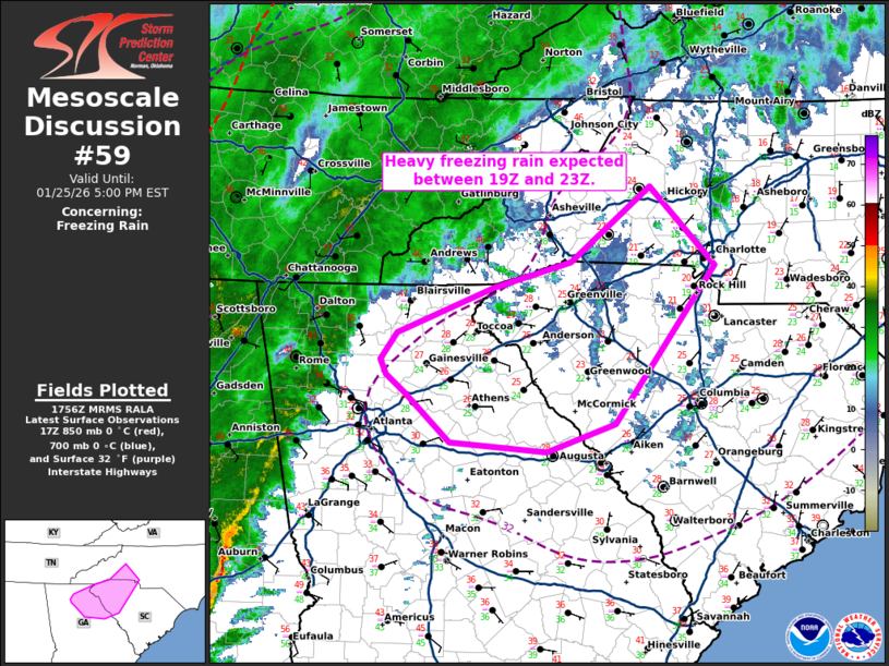
   Mesoscale Discussion 0059
   NWS Storm Prediction Center Norman OK
   1157 AM CST Sun Jan 25 2026

   Areas affected...northeast Georgia...western South Carolina...and
   parts of western North Carolina

   Concerning...Freezing rain

   Valid 251757Z - 252200Z

   SUMMARY...Heavy freezing rain is expected between 19Z and 23Z this
   afternoon.

   DISCUSSION...Persistent cold air damming persists in the lee of the
   Appalachians and into northern Georgia. An expansive area of
   stratiform rain will overspread this cold air this afternoon and
   result in moderate to heavy freezing rain.

   Heavy precipitation rates will likely warm temperatures a few
   degrees which may limit freezing rain efficiency in areas that are
   currently 31-32F. However, where temperatures are currently in the
   20s, northeast of Atlanta and eastward, expect below freezing
   temperatures to persist within the wedge. Additionally, a meso-low,
   analyzed on the 17Z surface chart in east-central Alabama, will move
   east into central Georgia which will alleviate any chance for
   erosion of the cold wedge and perhaps reinforce the westerly flow
   across northern Georgia.

   As a result, moderate to heavy precipitation with temperatures in
   the mid to upper 20s will result in significant ice accumulation
   between 19Z and 23Z from northeast Georgia into western South
   Carolina and into portions of southeast North Carolina. Given the
   expectation for relatively efficient ice accretion and QPF of 0.5 to
   0.7 inches, expect another 0.25" to 0.5" of ice accretion this
   afternoon and early evening.

   ..Bentley.. 01/25/2026

   ...Please see www.spc.noaa.gov for graphic product...

   ATTN...WFO...CAE...GSP...FFC...

   LAT...LON   34068403 34228423 34348429 34578412 34968313 35198233
               35838150 35158082 33798187 33568258 33638358 34068403
|
|
|
Top/All Mesoscale Discussions/Forecast Products/Home |
|
Source link