| Mesoscale Discussion 56 | |
| < Previous MD | |
|
|
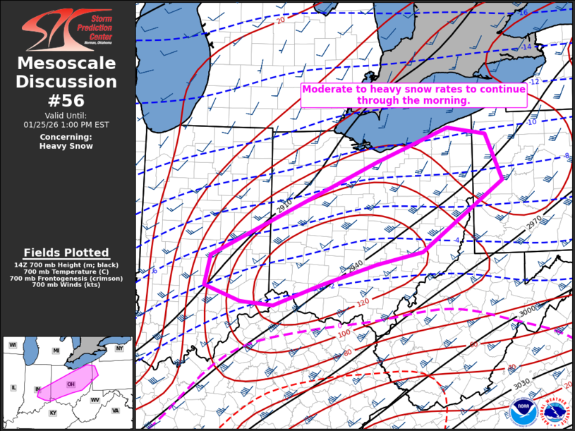
   Mesoscale Discussion 0056
   NWS Storm Prediction Center Norman OK
   0900 AM CST Sun Jan 25 2026

   Areas affected...Central Indiana to Western Pennsylvania

   Concerning...Heavy snow

   Valid 251500Z - 251800Z

   SUMMARY...Moderate to heavy snow rates to continue through the
   morning.

   DISCUSSION...A broad zone of isentropic ascent and frontogenesis
   across the Ohio Valley continues to support a widespread region of
   moderate snowfall this morning. Within this broad zone, heavier
   bands of snow with rates of 1+ inches per hour are being observed.
   This appears to be near the corridor of maximum 700mb frontogenesis
   based on SPC mesoanalysis. The peak of this frontogenesis appears to
   be from near Dayton, OH to Pittsburgh through 18Z before weakening
   thereafter.

   This also corresponds to a narrow zone 50 to 100 miles north of the
   sleet/snow transition zone which based on KILN Correlation
   Coefficient seems to have stalled southeast of I-71.

   Expect this zone of heavier rates to continue through the morning
   before weakening by early afternoon as the primary storm system
   shifts farther east and frontogenesis weakens.

   ..Bentley.. 01/25/2026

   ...Please see www.spc.noaa.gov for graphic product...

   ATTN...WFO...PBZ...RLX...CLE...ILN...IWX...IND...

   LAT...LON   39688605 41218256 41768104 41658024 40917988 39758159
               39568256 39228372 38898472 38948541 39208616 39688605
|
|
|
Top/All Mesoscale Discussions/Forecast Products/Home |
|
Source link