| Mesoscale Discussion 55 | |
| < Previous MD Next MD > | |

|
|
Mesoscale Discussion 0055
NWS Storm Prediction Center Norman OK
0839 AM CST Sun Jan 25 2026
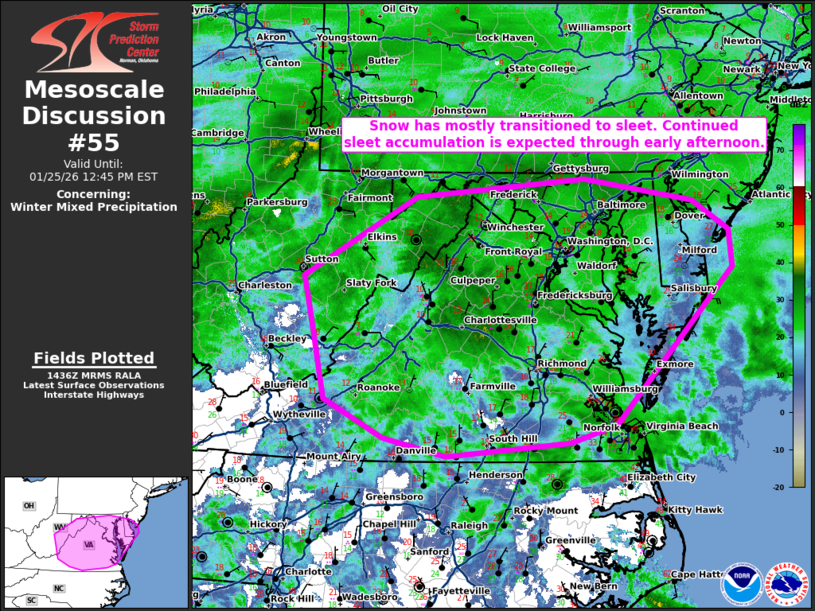
Areas affected...Eastern West Virginia and Virginia into the
DelMarva.
Concerning...Winter mixed precipitation
Valid 251439Z - 251745Z
SUMMARY...Snow has mostly transitioned to sleet from eastern West
Virginia, across Virginia, and into the DelMarva.
DISCUSSION...Strong warm air advection has supported moderate
precipitation rates through the morning across West
Virginia/Virginia and into the Mid-Atlantic. The 12A IAD RAOB showed
a warm nose slightly below freezing at around 750mb with very strong
(80 knot) southwesterly flow at the altitude of the warm nose. As
such, this warm nose is quickly warming/advecting north and surface
observations of sleet across northeast Virginia and Maryland confirm
this transition. Any areas that remain snow this morning across
Virginia and Maryland will likely transition to sleet within the
next 1 to 2 hours given this strong warm air advection aloft.
Expect precipitation type to remain sleet even as this warm nose
continues to warm given the very cold temperatures at the top of the
boundary layer (-15C) at the KIAD, KRNK, and KGSO 12Z RAOBs. The
moderate precipitation will continue with sleet accumulation of 0.1
to 0.2 inches per hour expected.
..Bentley.. 01/25/2026
...Please see www.spc.noaa.gov for graphic product...
ATTN...WFO...PHI...AKQ...LWX...RNK...PBZ...RLX...
LAT...LON 38578068 39447911 39657676 39407524 39077473 38657469
36957632 36747696 36607868 36797956 37218037 37978054
38578068
|
|
|
Top/All Mesoscale Discussions/Forecast Products/Home |
|
Source link