| Mesoscale Discussion 54 | |
| < Previous MD | |

|
|
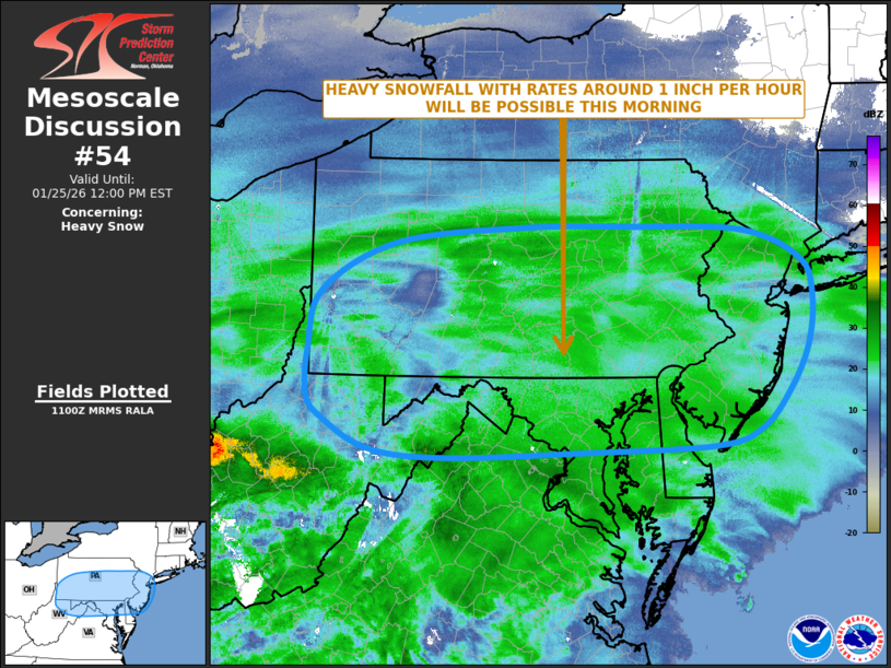
   Mesoscale Discussion 0054
   NWS Storm Prediction Center Norman OK
   0501 AM CST Sun Jan 25 2026

   Areas affected...Pennsylvania...New Jersey...Northern West
   Virginia...Northern Virginia...Northern Delaware...New Jersey...Far
   Southeast New York

   Concerning...Heavy snow

   Valid 251101Z - 251700Z

   SUMMARY...Heavy snowfall, with rates of around 1 inch per hour, is
   expected to continue to develop from parts of the upper Ohio Valley
   eastward to the Mid-Atlantic this morning.

   DISCUSSION...The latest mosaic radar imagery shows widespread
   snowfall ongoing from the Ohio Valley eastward into the
   Mid-Atlantic. This is occurring along a broad zone of strong
   isentropic ascent, aided by warm advection associated with a 50 to
   60 knot low-level speed max over the southern Appalachians. The exit
   region of this feature will continue to move northward this morning
   into the upper Ohio Valley and northern Mid-Atlantic, helping to
   gradually intensify snowfall rates. This will result in areas of
   heavy snow from Pennsylvania and northern Virginia eastward to New
   Jersey and far southeastern New York. Snowfall rates of 1 inch per
   hour will be possible within the more well-defined bands that setup.
   The heavy snowfall potential from Pennsylvania and New Jersey
   northward should continue through the mid to late morning. In
   northern Virginia, Maryland and Delaware, a changeover to freezing
   rain is expected by late morning.

   ..Broyles/Mosier.. 01/25/2026

   ...Please see www.spc.noaa.gov for graphic product...

   ATTN...WFO...OKX...PHI...BGM...CTP...LWX...PBZ...RLX...

   LAT...LON   41127934 41297761 41297613 41247459 40947379 40557364
               40037371 39567396 39167436 38997498 38927678 38877868
               38967970 39288035 39518054 40008053 40608035 41127934
|
|
|
Top/All Mesoscale Discussions/Forecast Products/Home |
|
Source link